Myportheritage
Menu
Code: HR_SO_18
Location / Address: Dominisova ulica, 21210 Solin
Date of mapping:
Property tipology: Private
State of occupancy: Occupied
State of preservation: Need of minor interventions on non-structural elements - (Score = 2)
Level of practicability: Partial - (Score = 0.5)
Surrounding area: Yes - (Score = 1)
Area itself is restricted but surrounding lawn-like areas could be potentially used for temporary events.
Construction era: Contemporary Era (XIX a.C. – Today)
Buried archaeological remains: Low probability (based on the available Archaeological information) – (Score = 1);
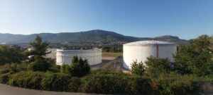
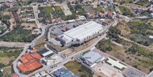
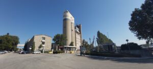
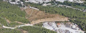
This site is occupied by 5 large silos varying in size, which are a part of loading and unloading operations of fuel and gas for INA- Industrija nafte. As such, this location has high importance in oil, fuel and gas supply for a wider area.
This building is within boundaries of ancient Salona harbor. Our Lady's Isle -the oldest Mariane shrine in Croatia, Gradina complex- fort-hill, Hollow church - The church is from the 11th century, linked with the coronation of Zvonimir as a Croatian king in 1075. Located nearby is Mramorna beach which is regurally visited by a handful of local people.
Distance: 2 km < D < 3 km
Organisation of internal spaces (related to "final intended use"): This is a site of five large silos of varying sizes. Silos are placed on a concrete floor base which is surrounded by flat grassy terrain. On the premises there is a loading bay for trucks and couple of smaller storage and control buildings.
Structure and Material Characteristics: Steel Structure
State of the structure: Silos are made out of steel and base is made out of concrete.
Electrical System: Presence of a public network in the Surrounding Area, presence of connections to the public network, presence of systems in the Infrastructure/Building/Archeologic Site – (Score = 3)
Sanitary Installation: Presence of a public network in the Surrounding Area, presence of connections to the public network, presence of systems in the Infrastructure/Building/Archeologic Site – (Score = 3)
Gasworks: Total lack of systems in the Infrastructure/Building/Archeological Site, total lack of connections to the public network and absence of a public network in the surrounding area – (Score = 0)
Existing infrastructure for private mobility: Presence of a paved road that lead to the Infrastructure/Building/Archeological Site, absence of a parking – (Score = 2)
Presence of a bicycle lane: no
Existing infrastructure for public means of transport: Easy to attain with public MoT (>500 and <1km) – (Score = 2)
The infrastructure/building/Archeological Site is considered as “Bounded Heritage”: no
Which is the level of complexity of the administrative procedures to be adopted to manage it in terms of renovation/retrofit or Temporary Uses activation?: Complicated – (Score = 0)
Privately owned property still in use.
Code: HR_SO_16
Location / Address: Krešimirova ulica 149 / 151, 21210 Solin
Date of mapping: 21/06/2020
Property tipology: Private
State of occupancy: Occupied
State of preservation: Need of minor interventions on non-structural elements - (Score = 2)
Level of practicability: None - (Score = 0)
Surrounding area: Yes - (Score = 1)
This location is a shipyard with heavy machinery operations. As such it is dangerous and unsafe place for temporary public events. There may be "surrounding safe areas" that could facilitate public events.
Construction era: Contemporary Era (XIX a.C. – Today)
Buried archaeological remains: High probability (based on the available Archaeological information) – (Score = 2);
This is a site of archeological remains of basilica and church of St. Peter. Also, many tombstones were found which suggests that there was a early christian burial ground at the site. Currently this area is used as a shipyard for renovation and building of smaller ships. There is a slipway for launching ships in to the sea, and there are also wharfs for docking the ships.
This site is near the ancient city of Salona. Our Lady's Isle -the oldest Mariane shrine in Croatia, Gradina complex- fort-hill, Hollow church - The church is from the 11th century, linked with the coronation of Zvonimir as a Croatian king in 1075.
Distance: 2 km < D < 3 km
Organisation of internal spaces (related to "final intended use"): Multiple different sized buildings.
Structure and Material Characteristics: Reinforced Concrete frame structure
State of the structure: Multiple typical industrial halls. Buildings are primarily made out of reinforced concrete and structuraly conceptualized as a frame structure.
Electrical System: Presence of a public network in the Surrounding Area, presence of connections to the public network, presence of systems in the Infrastructure/Building/Archeologic Site – (Score = 3)
Sanitary Installation: Presence of a public network in the Surrounding Area, presence of connections to the public network, presence of systems in the Infrastructure/Building/Archeologic Site – (Score = 3)
Gasworks: Total lack of systems in the Infrastructure/Building/Archeological Site, total lack of connections to the public network and absence of a public network in the surrounding area – (Score = 0)
Existing infrastructure for private mobility: Presence of a paved road that lead to the Infrastructure/Building/Archeological Site and of a parking in the surrounding area – (Score = 3)
Presence of a bicycle lane: no
Existing infrastructure for public means of transport: Easy to attain with public MoT (>500 and <1km) – (Score = 2)
The infrastructure/building/Archeological Site is considered as “Bounded Heritage”: no
Which is the level of complexity of the administrative procedures to be adopted to manage it in terms of renovation/retrofit or Temporary Uses activation?: Complicated – (Score = 0)
Privately owned property still in use.
Code: HR_SO_17
Location / Address: Draškovićeva ulica, 21210 Solin
Date of mapping: 21/06/2020
Property tipology: Private
State of occupancy: Occupied
State of preservation: Need of minor interventions on non-structural elements - (Score = 2)
Level of practicability: Partial - (Score = 0.5)
Surrounding area: Yes - (Score = 1)
This area is unsafe place for temporary public events cause of the loading and unloading operations. There may be "surrounding safe areas" that could facilitate public events.
Construction era: Contemporary Era (XIX a.C. – Today)
Buried archaeological remains: Low probability (based on the available Archaeological information) – (Score = 1);
This site is berth, which is a part of loading and unloading operations of fuel and gas for INA. INA or "Industrija nafte", is a Croatian multinational oil company. INA Group has leading role in Croatia's oil business, a strong regional position in the oil and gas exploration and production, oil processing, and oil product distribution activities. As such this location has high importance in oil supply for a wider area.
This building is within boundaries of ancient Salona harbor. Our Lady's Isle -the oldest Mariane shrine in Croatia, Gradina complex- fort-hill, Hollow church - The church is from the 11th century, linked with the coronation of Zvonimir as a Croatian king in 1075. Located nearby is Mramorna beach which is regurally visited by a handful of local people.
Distance: 2 km < D < 3 km
Organisation of internal spaces (related to "final intended use"): This building is a concrete berth. It is composed of a narrow pier like structure connecting a larger platform area, some 20 meters of the coast.
Structure and Material Characteristics: Other
State of the structure: It is made primarily of concrete. There is also a noticeable spatial presence of fuel and gas pipelines.
Electrical System: Presence of a public network in the Surrounding Area, total lack of systems in the Infrastructure/Building/Archeological Site, total lack of connections to the public network – (Score = 1)
Sanitary Installation: Presence of a public network in the Surrounding Area, total lack of systems in the Infrastructure/Building/Archeological Site, total lack of connections to the public network – (Score = 1)
Gasworks: Total lack of systems in the Infrastructure/Building/Archeological Site, total lack of connections to the public network and absence of a public network in the surrounding area – (Score = 0)
Existing infrastructure for private mobility: Presence of a dirt road that lead to the Infrastructure/Building/Archeological Site, absence of a paved road and of a parking – (Score = 1)
Presence of a bicycle lane: no
Existing infrastructure for public means of transport: Difficult to attain public MoT (>1 and <3 km) – (Score = 1)
The infrastructure/building/Archeological Site is considered as “Bounded Heritage”: no
Which is the level of complexity of the administrative procedures to be adopted to manage it in terms of renovation/retrofit or Temporary Uses activation?: Complicated – (Score = 0)
Privately owned property still in use.
Code: HR_SO_19
Location / Address: Put Majdana, 21210 Solin
Date of mapping: 21/06/2020
Property tipology: Private
State of occupancy: Partly Occupied
State of preservation: Need of interventions on structural framework - (Score = 1)
Level of practicability: Partial - (Score = 0.5)
Surrounding area: Yes - (Score = 1)
There are areas adequate for temporary use in vicinity.
Construction era: Contemporary Era (XIX a.C. – Today)
Buried archaeological remains: Low probability (based on the available Archaeological information) – (Score = 1);
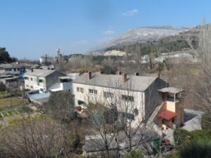
Near the spring of Jadro river, in the area of Majdan, the fifth Dalmatian cement factory was built in 1908. There was a great need for workforce housing, so several, topologically near identical buildings were built. Though today some of this housing is not to the living standard, in the past it was home to significant part of workforce for extended period of time.
Our Lady's Isle -the oldest Mariane shrine in Croatia, Archaelogical park of Salona, Hollow church - The church is from the 11th century, linked with the coronation of Zvonimir as a Croatian king in 1075
Distance: 2 km < D < 3 km
Organisation of internal spaces (related to "final intended use"): Multiple topologically near identical houses for communal living. Most buildings have two floors.
Structure and Material Characteristics: Bearing Masonry
State of the structure: Bearing masonry with wooden pitched roof structure, covered with cement sheets. Some minor changes have been made to the structure and layout of buildings.
Electrical System: Presence of a public network in the Surrounding Area, presence of connections to the public network, total lack systems in the Infrastructure/Building/Archeological Site – (Score = 2)
Sanitary Installation: Presence of a public network in the Surrounding Area, presence of connections to the public network, total lack systems in the Infrastructure/Building/Archeological Site – (Score = 2)
Gasworks: Total lack of systems in the Infrastructure/Building/Archeological Site, total lack of connections to the public network and absence of a public network in the surrounding area – (Score = 0)
Existing infrastructure for private mobility: Presence of a paved road that lead to the Infrastructure/Building/Archeological Site and of a parking in the surrounding area – (Score = 3)
Presence of a bicycle lane: no
Existing infrastructure for public means of transport: Easy to attain with public MoT (>500 and <1km) – (Score = 2)
The infrastructure/building/Archeological Site is considered as “Bounded Heritage”: no
Which is the level of complexity of the administrative procedures to be adopted to manage it in terms of renovation/retrofit or Temporary Uses activation?: Complicated – (Score = 0)
Area is partially public and partially privately owned.
Code: HR_SO_20
Location / Address: Banova ulica / Drašovićeva ulica / Ulica oko Svetog Kaje,21210 Solin
Date of mapping: 21/06/2020
Property tipology: Private
State of occupancy: Occupied
State of preservation: Need of interventions on structural framework - (Score = 1)
Level of practicability: Partial - (Score = 0.5)
Surrounding area: Yes - (Score = 1)
Buildings them self might not be available or adequate for temporary use but the events could be potentially facilitated in the surrounding area.
Construction era: Contemporary Era (XIX a.C. – Today)
Buried archaeological remains: Low probability (based on the available Archaeological information) – (Score = 1);
With the founding of the St. Kajo cement factory and its later development there was also a great need for workforce housing and other amenities. Multiple housing buildings were built, alongside office buildings and even a small cinema ("culture home"). Buildings in this settlement are topologically and stylistiacly differing. Quality of construction is also not on the same level for all the buildings. Though today some of these buildings are not to the living standard and are partly ruinous, in the past it was home to significant part of workforce for extended period of time.
Factory settlement St. Kajo is near the ancient city of Salona. Our Lady's Isle -the oldest Mariane shrine in Croatia, Gradina complex- fort-hill, Hollow church - The church is from the 11th century, linked with the coronation of Zvonimir as a Croatian king in 1075. Located nearby is Mramorna beach which is regularly visited by a handful of local people.
Distance: 2 km < D < 3 km
Organisation of internal spaces (related to "final intended use"): Multiple different buildings. Some are residential, some are commercial and some are in a ruined state.
Structure and Material Characteristics: Other
State of the structure: All buildings are one to two stories high and have pitched roofs. Different materials were used in construction of these buildings. Main ones being clay bricks, poured concrete, stone, asbestos- cement roof paneling.
Electrical System: Presence of a public network in the Surrounding Area, presence of connections to the public network, presence of systems in the Infrastructure/Building/Archeologic Site – (Score = 3)
Sanitary Installation: Presence of a public network in the Surrounding Area, presence of connections to the public network, presence of systems in the Infrastructure/Building/Archeologic Site – (Score = 3)
Gasworks: Total lack of systems in the Infrastructure/Building/Archeological Site, total lack of connections to the public network and absence of a public network in the surrounding area – (Score = 0)
Existing infrastructure for private mobility: Presence of a paved road that lead to the Infrastructure/Building/Archeological Site, absence of a parking – (Score = 2)
Presence of a bicycle lane: no
Existing infrastructure for public means of transport: Easy to attain with public MoT (>500 and <1km) – (Score = 2)
The infrastructure/building/Archeological Site is considered as “Bounded Heritage”: no
Which is the level of complexity of the administrative procedures to be adopted to manage it in terms of renovation/retrofit or Temporary Uses activation?: Complicated – (Score = 0)
Area is partially public and partially privately owned.
Code: HR_SO_15
Location / Address: Ulica Hrvatskih branitelja, 21210 Solin
Date of mapping: 21/06/2020
Property tipology: Private
State of occupancy: Occupied
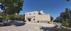
State of preservation: Well preserved (no need of intervention) - (Score = 3)
Level of practicability: Partial - (Score = 0.5)
Surrounding area: No - (Score = 0)
Though this is a privately owned bottling operations it could be possible to organize temporary public events in some parts of building, if agreed upon by owner.
Construction era: Contemporary Era (XIX a.C. – Today)
Buried archaeological remains: Low probability (based on the available Archaeological information) – (Score = 1);
This industrial complex was originally erected as bottlery (manufacturing plant). Today, it is used as storage and distribution center. Positioned on top of the hill, it is highly visible part of Solins' skyline.
Our Lady's Isle -the oldest Mariane shrine in Croatia, Gradina complex- fort-hill, Hollow church - The church is from the 11th century, linked with the coronation of Zvonimir as a Croatian king in 1075. Ancient Salona is in vicinity.
Distance: 2 km < D < 3 km
Organisation of internal spaces (related to "final intended use"): This area is a place of Coca-Cola a bottler operation. Building also houses offices, warehouse and outdoor truck loading bays.
Structure and Material Characteristics: Reinforced Concrete frame structure
State of the structure: Reinforced Concrete frame structure covered with steel thermoinsulated panels.
Electrical System: Presence of a public network in the Surrounding Area, presence of connections to the public network, presence of systems in the Infrastructure/Building/Archeologic Site – (Score = 3)
Sanitary Installation: Presence of a public network in the Surrounding Area, presence of connections to the public network, presence of systems in the Infrastructure/Building/Archeologic Site – (Score = 3)
Gasworks: Total lack of systems in the Infrastructure/Building/Archeological Site, total lack of connections to the public network and absence of a public network in the surrounding area – (Score = 0)
Existing infrastructure for private mobility: Presence of a paved road that lead to the Infrastructure/Building/Archeological Site and of a parking in the surrounding area – (Score = 3)
Presence of a bicycle lane: no
Existing infrastructure for public means of transport: Easy to attain with public MoT (>500 and <1km) – (Score = 2)
The infrastructure/building/Archeological Site is considered as “Bounded Heritage”: yes
Which is the level of complexity of the administrative procedures to be adopted to manage it in terms of renovation/retrofit or Temporary Uses activation?: Complicated – (Score = 0)
Privately owned property still in use.
Code: HR_SO_14
Location / Address: Salonitanska cesta 19, 21210 Solin
Date of mapping: 21/06/2020
Property tipology: Private
State of occupancy: Occupied
State of preservation: Need of minor interventions on non-structural elements - (Score = 2)
Level of practicability: None - (Score = 0)
Surrounding area: Yes - (Score = 1)
This location is a cement factory with heavy machinery operations. As such it is dangerous and unsafe place for temporary public events. There may be "surrounding safe areas" that could facilitate public events.
Construction era: Contemporary Era (XIX a.C. – Today)
Buried archaeological remains: Low probability (based on the available Archaeological information) – (Score = 1);
This location is a cement factory with heavy machinery operations. As such it is dangerous and unsafe place for temporary public events. There may be "surrounding safe areas" that could facilitate public events.
This industrial complex is near the boundaries of ancient Salona. Our Lady's Isle -the oldest Mariane shrine in Croatia, Gradina complex- fort-hill, Hollow church - The church is from the 11th century, linked with the coronation of Zvonimir as a Croatian king in 1075. Located nearby is Mramorna beach which is regularly visited by a handful of local people.
Distance: 2 km < D < 3 km
Organisation of internal spaces (related to "final intended use"): Area is organized in multiple buildings and silos of varying size. Some of the buildings are interconnected, while some are isolated.
Structure and Material Characteristics: Reinforced Concrete frame structure
State of the structure: Typical industrial building with large production halls. It is primarily made out of reinforced concrete and structurally conceptualized as a frame structure.
Electrical System: Presence of a public network in the Surrounding Area, presence of connections to the public network, presence of systems in the Infrastructure/Building/Archeologic Site – (Score = 3)
Sanitary Installation: Presence of a public network in the Surrounding Area, presence of connections to the public network, presence of systems in the Infrastructure/Building/Archeologic Site – (Score = 3)
Gasworks: Total lack of systems in the Infrastructure/Building/Archeological Site, total lack of connections to the public network and absence of a public network in the surrounding area – (Score = 0)
Existing infrastructure for private mobility: Presence of a paved road that lead to the Infrastructure/Building/Archeological Site and of a parking in the surrounding area – (Score = 3)
Presence of a bicycle lane: no
Existing infrastructure for public means of transport: Easy to attain with public MoT (>500 and <1km) – (Score = 2)
The infrastructure/building/Archeological Site is considered as “Bounded Heritage”: no
Which is the level of complexity of the administrative procedures to be adopted to manage it in terms of renovation/retrofit or Temporary Uses activation?: Complicated – (Score = 0)
Privately owned property still in use.
Code: HR_SO_13
Location / Address: Ulica nadbiskupa Ante Jurića / Pri sela, 21210 Solin
Date of mapping: 21/06/2021
Property tipology: Public
State of occupancy: Partly Occupied
State of preservation: Need of minor interventions on non-structural elements - (Score = 2)
Level of practicability: Total - (Score = 1)
Surrounding area: Yes - (Score = 1)
It is possible to organize public events on the premises.
Construction era: Contemporary Era (XIX a.C. – Today)
Buried archaeological remains: Absence of buried Archaeological remains or absence of Archaeological information about the site – (Score = 0);
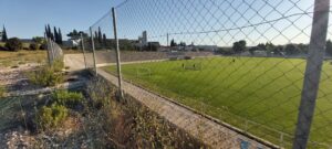
Area is a remediated marl quarry. Many residents used to work and live in the close vicinity of the quarry. It was a major source of raw material for cement production that economically developed the area. Today it is publicly used for sports and recreation (mainly football).
This site is near the boundaries of ancient Salona. Our Lady's Isle -the oldest Mariane shrine in Croatia, Gradina complex- fort-hill, Hollow church - The church is from the 11th century, linked with the coronation of Zvonimir as a Croatian king in 1075.
Distance: 2 km < D < 3 km
Organisation of internal spaces (related to "final intended use"): Mostly flat open terrain. Parts of it are organized and arranged to accommodate football fields and spectator stands with several temporary utility buildings. Other parts of the location are unused and mostly grassy.
Structure and Material Characteristics: Other
State of the structure: Low walls and fences of football fields.
Electrical System: Presence of a public network in the Surrounding Area, presence of connections to the public network, presence of systems in the Infrastructure/Building/Archeologic Site – (Score = 3)
Sanitary Installation: Presence of a public network in the Surrounding Area, presence of connections to the public network, presence of systems in the Infrastructure/Building/Archeologic Site – (Score = 3)
Gasworks: Total lack of systems in the Infrastructure/Building/Archeological Site, total lack of connections to the public network and absence of a public network in the surrounding area – (Score = 0)
Existing infrastructure for private mobility: Presence of a paved road that lead to the Infrastructure/Building/Archeological Site, absence of a parking – (Score = 2)
Presence of a bicycle lane: no
Existing infrastructure for public means of transport: Easy to attain with public MoT (>500 and <1km) – (Score = 2)
The infrastructure/building/Archeological Site is considered as “Bounded Heritage”: no
Which is the level of complexity of the administrative procedures to be adopted to manage it in terms of renovation/retrofit or Temporary Uses activation?: Complicated – (Score = 0)
Area is publicly owned (municipality) and parts of it are managed and used for football practice.
Code: HR_SO_12
Location / Address: Gajeva ulica / Put Majdana, 21210 Solin
Date of mapping: 21/06/2020
Property tipology: Private
State of occupancy: Partly Occupied
State of preservation: Mostly rickety/unsafe - (Score = 0)
Level of practicability: Partial - (Score = 0.5)
Surrounding area: Yes - (Score = 1)
Area is used as a shooting range. Location can be accessed only via dirt road.
Construction era: Contemporary Era (XIX a.C. – Today)
Buried archaeological remains: Absence of buried Archaeological remains or absence of Archaeological information about the site – (Score = 0);
This was formerly exploited marl quarry. When exploitation stopped it was filled with variety of hazardous materials like asbestos. Today area is remediated and used for shooting practice.
Our Lady's Isle -the oldest Mariane shrine in Croatia, Gradina complex- fort-hill, Hollow church - The church is from the 11th century, linked with the coronation of Zvonimir as a Croatian king in 1075. Ancient Salona is in vicinity.
Distance: 2 km < D < 3 km
Organisation of internal spaces (related to "final intended use"): Former quarry was until recently used as storage pit for hazardous waste. Today it is remediated and safe for public use, primarily shooting practice. It's a mostly grassy slope with serpentine access road.
Structure and Material Characteristics: Other
State of the structure: There are paved surfaces with shooting props and targets.
Electrical System: Total lack of systems in the Infrastructure/Building/Archeological Site, total lack of connections to the public network and absence of a public network in the surrounding area – (Score = 0)
Sanitary Installation: Total lack of systems in the Infrastructure/Building/Archeological Site, total lack of connections to the public network and absence of a public network in the surrounding area – (Score = 0)
Gasworks: Total lack of systems in the Infrastructure/Building/Archeological Site, total lack of connections to the public network and absence of a public network in the surrounding area – (Score = 0)
Existing infrastructure for private mobility: Presence of a dirt road that lead to the Infrastructure/Building/Archeological Site, absence of a paved road and of a parking – (Score = 1)
Presence of a bicycle lane: no
Existing infrastructure for public means of transport: Unattainable with public MoT (>3km) – (Score = 0)
The infrastructure/building/Archeological Site is considered as “Bounded Heritage”: no
Which is the level of complexity of the administrative procedures to be adopted to manage it in terms of renovation/retrofit or Temporary Uses activation?: Complicated – (Score = 0)
Area is partially public and partially privately owned.

Code: HR_SO_11
Location / Address: Vranjički put 16, 21210 Solin
Date of mapping: 21/06/2020
Property tipology: Private
State of occupancy: Occupied
State of preservation: Need of minor interventions on non-structural elements - (Score = 2)
Level of practicability: Partial - (Score = 0.5)
Surrounding area: No - (Score = 0)
Brewery area could possibly facilitate public events. However, this is privately owned area and production process would be hindered or disrupted and could be potentially hazardous for general public. That is why it is concluded that this location is partially practicable and not entirely safe.
Construction era: Contemporary Era (XIX a.C. – Today)
Buried archaeological remains: Low probability (based on the available Archaeological information) – (Score = 1);
Brewery area is built in the latter half of 20th century. It was located in the coastal area within an industrial zone. Since its establishment, brewery has had an significant economical importance for the workers, who are mainly local residents.
This building is within boundaries of ancient Salona. Our Lady's Isle -the oldest Mariane shrine in Croatia, Gradina complex- fort-hill, Hollow church - The church is from the 11th century, linked with the coronation of Zvonimir as a Croatian king in 1075.
Distance: 2 km < D < 3 km
Organisation of internal spaces (related to "final intended use"): N/P
Structure and Material Characteristics: Reinforced Concrete frame structure
State of the structure: This is a typical industrial building with large production halls. It is primarily made out of reinforced concrete and structurally conceptualized as frame structure.
Electrical System: Presence of a public network in the Surrounding Area, presence of connections to the public network, presence of systems in the Infrastructure/Building/Archeologic Site – (Score = 3)
Sanitary Installation: Presence of a public network in the Surrounding Area, presence of connections to the public network, presence of systems in the Infrastructure/Building/Archeologic Site – (Score = 3)
Gasworks: Total lack of systems in the Infrastructure/Building/Archeological Site, total lack of connections to the public network and absence of a public network in the surrounding area – (Score = 0)
Existing infrastructure for private mobility: Presence of a paved road that lead to the Infrastructure/Building/Archeological Site and of a parking in the surrounding area – (Score = 3)
Presence of a bicycle lane: no
Existing infrastructure for public means of transport: Difficult to attain public MoT (>1 and <3 km) – (Score = 1)
The infrastructure/building/Archeological Site is considered as “Bounded Heritage”: no
Which is the level of complexity of the administrative procedures to be adopted to manage it in terms of renovation/retrofit or Temporary Uses activation?: Complicated – (Score = 0)
Site is privately owned and in use.
Code: HR_SO_10
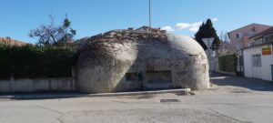
Location / Address: FIRST: Ivana Pavla II, Širina, 21210 Solin
SECOND: Ulica kralja Zvonimira, 21210 Solin
THIRD: Put Majdana, 21210 Solin
Date of mapping: 21/02/2020
Property tipology: Private
State of occupancy: Partly Occupied
State of preservation: Need of interventions on structural framework - (Score = 1)
Level of practicability: Partial - (Score = 0.5)
Surrounding area: Yes - (Score = 1)
Third bunker is safe, has amenities and is suitable for TU.
Construction era: Contemporary Era (XIX a.C. – Today)
Buried archaeological remains: Absence of buried Archaeological remains or absence of Archaeological information about the site – (Score = 0);
These bunkers have been made during the first half of twentieth century as a part of a security network intended to guard major connections leading to Solin and Split, important infrastructure and port/terminal areas.
Our Lady's Isle -the oldest Mariane shrine in Croatia, Gradina complex- fort-hill, Hollow church - The church is from the 11th century, linked with the coronation of Zvonimir as a Croatian king in 1075. Ancient Salona is in vicinity.
Distance: 2 km < D < 3 km
Organisation of internal spaces (related to "final intended use"): n/a
Structure and Material Characteristics: Other
State of the structure: Bunkers are made of cast concrete.
Electrical System: Presence of a public network in the Surrounding Area, presence of connections to the public network, presence of systems in the Infrastructure/Building/Archeologic Site – (Score = 3)
Sanitary Installation: Total lack of systems in the Infrastructure/Building/Archeological Site, total lack of connections to the public network and absence of a public network in the surrounding area – (Score = 0)
Gasworks: Total lack of systems in the Infrastructure/Building/Archeological Site, total lack of connections to the public network and absence of a public network in the surrounding area – (Score = 0)
Existing infrastructure for private mobility: Presence of a paved road that lead to the Infrastructure/Building/Archeological Site, absence of a parking – (Score = 2)
Presence of a bicycle lane: no
Existing infrastructure for public means of transport: Difficult to attain public MoT (>1 and <3 km) – (Score = 1)
The infrastructure/building/Archeological Site is considered as “Bounded Heritage”: no
Which is the level of complexity of the administrative procedures to be adopted to manage it in terms of renovation/retrofit or Temporary Uses activation?: Complicated – (Score = 0)
First bunker is in public ownership but remaining two are privately owned.
Code: HR_SO_09
Location / Address: Put Majdana, 21210 Solin
Date of mapping: 21/02/2020
Property tipology: Private
State of occupancy: Partly Occupied
State of preservation: Mostly rickety/unsafe - (Score = 0)
Level of practicability: Partial - (Score = 0.5)
Surrounding area: Yes - (Score = 1)
Part of the building is a ruin and the other part is privately owned and used daily as a boxing gym. However, square in front of the building can be used as TU.
Construction era: Contemporary Era (XIX a.C. – Today)
Buried archaeological remains: Absence of buried Archaeological remains or absence of Archaeological information about the site – (Score = 0);
Near the spring of Jadro river, in the area of Majdan, the fifth Dalmatian cement factory was built in 1908.
In accordance with the post-war social paradigm the Culture center was built in 1954. The Cultural centre has a dance and cinema hall, a meeting room, a library and a reading room, raising the standard of cultural and social functions in Majdan, but also in the wider Solin region. We can credit the designs to architect Franjo Buškariol who, along with the enclosed settlements, formed a new square, creating an architectural structure that stands out among the contemporary buildings of social purpose built for the Dalmatian cement factory.
The building was burnt at the beginning of the 1990s and has not been integrally renovated to date. Its architectural value and potential of renovation have been actualized by recent urban transformation processes in the surrounding area.
Our Lady's Isle -the oldest Mariane shrine in Croatia, Archaelogical park of Salona, Hollow church - The church is from the 11th century, linked with the coronation of Zvonimir as a Croatian king in 1075
Distance: 2 km < D < 3 km
Organisation of internal spaces (related to "final intended use"): Part of the building is uncleared ruing and the other part is adapted and used daily as a boxing gym.
Structure and Material Characteristics: Reinforced Concrete frame structure
State of the structure: Building is made of rectangular cut stone and concrete. Roof is a wooden construction covered with asbestos panels. Part of a building was destroyed by fire.
Electrical System: Presence of a public network in the Surrounding Area, presence of connections to the public network, presence of systems in the Infrastructure/Building/Archeologic Site – (Score = 3)
Sanitary Installation: Presence of a public network in the Surrounding Area, presence of connections to the public network, presence of systems in the Infrastructure/Building/Archeologic Site – (Score = 3)
Gasworks: Total lack of systems in the Infrastructure/Building/Archeological Site, total lack of connections to the public network and absence of a public network in the surrounding area – (Score = 0)
Existing infrastructure for private mobility: Presence of a paved road that lead to the Infrastructure/Building/Archeological Site, absence of a parking – (Score = 2)
Presence of a bicycle lane: no
Existing infrastructure for public means of transport: Difficult to attain public MoT (>1 and <3 km) – (Score = 1)
The infrastructure/building/Archeological Site is considered as “Bounded Heritage”: no
Which is the level of complexity of the administrative procedures to be adopted to manage it in terms of renovation/retrofit or Temporary Uses activation?: Complicated – (Score = 0)
Ownership status is not completely clear. Castrate parcel does not exist for this building.
Code: HR_SO_08
Location / Address: Krešimirova ul. 147, 21211, Vranjic, Croatia
Date of mapping: 21/02/2020
Property tipology: Private
State of occupancy: Partly Occupied
State of preservation: Need of interventions on structural framework - (Score = 1)
Level of practicability: Partial - (Score = 0.5)
Surrounding area: Yes - (Score = 1)
Site is partially used for storage and service facility. However, there is a nearby beach available for temporary use.
Construction era: Contemporary Era (XIX a.C. – Today)
Buried archaeological remains: High probability (based on the available Archaeological information) – (Score = 2);
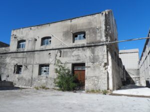
This is a site of archeological remains of basilica and church of St. Peter. Also, many tombstones were found which suggests that there was a early christian burial ground at the site.
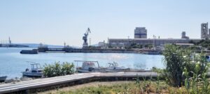
First industrial and port facilities, intended for storage and shipment of cement from the nearby Majdan factory, were built from 1909-1921, along with the railway connecting them. Asbestos factory "Salonit" was found in 1921 and existing facilities were expanded to accommodate the production of asbestos prefabricates. Use and manufacture of asbestos products in Croatia was banned in 2006, production was halted and factory was subsequently closed. Since then, factory site is in disrepair and is partially used as storage area.
This building is within boundaries of ancient Salona. Our Lady's Isle -the oldest Mariane shrine in Croatia, Gradina complex- fort-hill, Hollow church - The church is from the 11th century, linked with the coronation of Zvonimir as a Croatian king in 1075.
Distance: 2 km < D < 3 km
Organisation of internal spaces (related to "final intended use"): Industrial production and storage halls with ancillary facilities. Port facilities with cranes.
Structure and Material Characteristics: Reinforced Concrete frame structure
State of the structure: Mostly reinforced concrete and steel structures.
Electrical System: Presence of a public network in the Surrounding Area, presence of connections to the public network, presence of systems in the Infrastructure/Building/Archeologic Site – (Score = 3)
Sanitary Installation: Presence of a public network in the Surrounding Area, presence of connections to the public network, presence of systems in the Infrastructure/Building/Archeologic Site – (Score = 3)
Gasworks: Total lack of systems in the Infrastructure/Building/Archeological Site, total lack of connections to the public network and absence of a public network in the surrounding area – (Score = 0)
Existing infrastructure for private mobility: Presence of a paved road that lead to the Infrastructure/Building/Archeological Site, absence of a parking – (Score = 2)
Presence of a bicycle lane: no
Existing infrastructure for public means of transport: Easy to attain with public MoT (>500 and <1km) – (Score = 2)
The infrastructure/building/Archeological Site is considered as “Bounded Heritage”: no
Which is the level of complexity of the administrative procedures to be adopted to manage it in terms of renovation/retrofit or Temporary Uses activation?: Complicated – (Score = 0)
Site is partially used and privately owned.
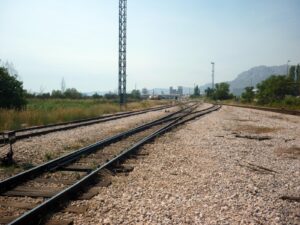
Code: HR_SO_07
Location / Address: Draškovićeva ulica, 21210 Solin
Date of mapping: 21/02/2020
Property tipology: Private
State of occupancy: Occupied
State of preservation: Need of minor interventions on non-structural elements - (Score = 2)
Level of practicability: Partial - (Score = 0.5)
Surrounding area: Yes - (Score = 1)
It is possible to visit the site but it is not safe because it is partially used for train housing, repair and heavy machinery storage. However, there is a nearby beach available for temporary use.
Construction era: Contemporary Era (XIX a.C. – Today)
Buried archaeological remains: High probability (based on the available Archaeological information) – (Score = 2);
This classification yard was built as a expansion of railway route connecting Split and the rest of Croatia. It was important for sorting wagons carying various goods thorough and to Solin and Split ports, terminals, shipyards and industrial facilities. With change of logistical transportation this classification yard has lost much of it's importance. Now it is over sized and is a potential brownfield site.
This building is within boundaries of ancient Salona. Our Lady's Isle -the oldest Mariane shrine in Croatia, Gradina complex- fort-hill, Hollow church - The church is from the 11th century, linked with the coronation of Zvonimir as a Croatian king in 1075. Located nearby is Mramorna beach which is regularly visited by a hand full of local people.
Distance: 2 km < D < 3 km
Organisation of internal spaces (related to "final intended use"): Series of paralele railroad lines used for sorting and classification of vagons carrying different goods and/or intended for different destinations.
Structure and Material Characteristics: Other
State of the structure: Typical two track railroad.
Electrical System: Presence of a public network in the Surrounding Area, presence of connections to the public network, total lack systems in the Infrastructure/Building/Archeological Site – (Score = 2)
Sanitary Installation: Presence of a public network in the Surrounding Area, total lack of systems in the Infrastructure/Building/Archeological Site, total lack of connections to the public network – (Score = 1)
Gasworks: Total lack of systems in the Infrastructure/Building/Archeological Site, total lack of connections to the public network and absence of a public network in the surrounding area – (Score = 0)
Existing infrastructure for private mobility: Presence of a paved road that lead to the Infrastructure/Building/Archeological Site, absence of a parking – (Score = 2)
Presence of a bicycle lane: no
Existing infrastructure for public means of transport: Difficult to attain public MoT (>1 and <3 km) – (Score = 1)
The infrastructure/building/Archeological Site is considered as “Bounded Heritage”: no
Which is the level of complexity of the administrative procedures to be adopted to manage it in terms of renovation/retrofit or Temporary Uses activation?: Complicated – (Score = 0)
Classification yard is owned by state company, Croatian Railways, and is partialy used.
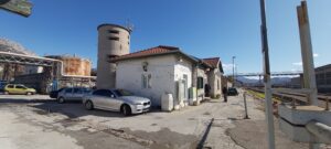
Code: HR_SO_06
Location / Address: Draškovićeva ulica, 21210 Solin
Date of mapping: 21/02/2020
Property tipology: Private
State of occupancy: Occupied
State of preservation: Need of interventions on structural framework - (Score = 1)
Level of practicability: Partial - (Score = 0.5)
Surrounding area: Yes - (Score = 1)
It is possible to visit the building but it is not practical because it is used as a railway station. However, there is a nearby beach available for temporary use.
Construction era: Contemporary Era (XIX a.C. – Today)
Buried archaeological remains: High probability (based on the available Archaeological information) – (Score = 2);
This was a reception building made as part of railway route connecting Split and Siverić, and later rest of Europe. Building was built in 1877. It's typologically simmilar to other reception buildings on the route from this period.
This building is within boundaries of ancient Salona. Our Lady's Isle -the oldest Mariane shrine in Croatia, Gradina complex- fort-hill, Hollow church - The church is from the 11th century, linked with the coronation of Zvonimir as a Croatian king in 1075. Located nearby is Mramorna beach which is regularly visited by a handful of local people.
Distance: 2 km < D < 3 km
Organisation of internal spaces (related to "final intended use"): Building is used as intended, reception building.
Structure and Material Characteristics: Bearing Masonry
State of the structure: Building is made of rectangular cut stones on all sides. Roof is a wooden construction covered with red clay tiles.
Electrical System: Presence of a public network in the Surrounding Area, presence of connections to the public network, presence of systems in the Infrastructure/Building/Archeologic Site – (Score = 3)
Sanitary Installation: Presence of a public network in the Surrounding Area, presence of connections to the public network, presence of systems in the Infrastructure/Building/Archeologic Site – (Score = 3)
Gasworks: Total lack of systems in the Infrastructure/Building/Archeological Site, total lack of connections to the public network and absence of a public network in the surrounding area – (Score = 0)
Existing infrastructure for private mobility: Presence of a paved road that lead to the Infrastructure/Building/Archeological Site, absence of a parking – (Score = 2)
Presence of a bicycle lane: no
Existing infrastructure for public means of transport: Easy to attain with public MoT (>500 and <1km) – (Score = 2)
The infrastructure/building/Archeological Site is considered as “Bounded Heritage”: yes
Which is the level of complexity of the administrative procedures to be adopted to manage it in terms of renovation/retrofit or Temporary Uses activation?: Complicated – (Score = 0)
Building is owned by state company, Croatian Railways, and is partially used.
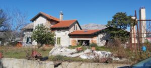
Code: HR_SO_05
Location / Address: Ulica Salonitanskih mučenika, 21210 Solin
Date of mapping: 21/02/2022
Property tipology: Private
State of occupancy: Occupied
State of preservation: Need of interventions on structural framework - (Score = 1)
Level of practicability: None - (Score = 0)
Surrounding area: No - (Score = 0)
Building is owned by state company, Croatian Railways, and is occupied. Land surrounding the building is privately owned.
Construction era: Contemporary Era (XIX a.C. – Today)
Buried archaeological remains: Low probability (based on the available Archaeological information) – (Score = 1);
This was a reception building made during Austro-Hungarian Empire. It was made as a part of railway route intended to connect Split and Sarajevo. However, railroad was never finished past Sinj. It was colloquially called "Rera". This reception building was made in 1901-1902. It's typologicaly similar to other reception buildings on the route from this period.
Our Lady's Isle -the oldest Mariane shrine in Croatia, Gradina complex- fort-hill, Hollow church - The church is from the 11th century, linked with the coronation of Zvonimir as a Croatian king in 1075. Ancient Salona is in relative vicinity.
Distance: 2 km < D < 3 km
Organisation of internal spaces (related to "final intended use"): Primarily it was built to be a railway/reception station and guard house. Today its spatial layout and usage is not clear.
Structure and Material Characteristics: Bearing Masonry
State of the structure: Building is made of rectangular cut stones on all sides. Roof is a wooden construction covered with red clay tiles.
Electrical System: Presence of a public network in the Surrounding Area, presence of connections to the public network, presence of systems in the Infrastructure/Building/Archeologic Site – (Score = 3)
Sanitary Installation: Presence of a public network in the Surrounding Area, presence of connections to the public network, presence of systems in the Infrastructure/Building/Archeologic Site – (Score = 3)
Gasworks: Total lack of systems in the Infrastructure/Building/Archeological Site, total lack of connections to the public network and absence of a public network in the surrounding area – (Score = 0)
Existing infrastructure for private mobility: Presence of a paved road that lead to the Infrastructure/Building/Archeological Site and of a parking in the surrounding area – (Score = 3)
Presence of a bicycle lane: no
Existing infrastructure for public means of transport: Easy to attain with public MoT (>500 and <1km) – (Score = 2)
The infrastructure/building/Archeological Site is considered as “Bounded Heritage”: yes
Which is the level of complexity of the administrative procedures to be adopted to manage it in terms of renovation/retrofit or Temporary Uses activation?: Complicated – (Score = 0)
Building is owned by state company, Croatian Railways, and is occupied. Land surrounding the building is privately owned.
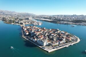
Code: HR_SO_04
Location / Address: Vranjic, Solin
Date of mapping: 21/02/2020
Property tipology: Private
State of occupancy: Occupied
State of preservation: Need of minor interventions on non-structural elements - (Score = 2)
Level of practicability: Partial - (Score = 0.5)
Surrounding area: Yes - (Score = 1)
It is possible to organize TU. However, because of the limited spacial characteristic of seafront it would be quite demanding and restricting regarding the number of visitors.
Construction era: Medieval Era (VIII - XIV a.C.)
Buried archaeological remains: High probability (based on the available Archaeological information) – (Score = 2);
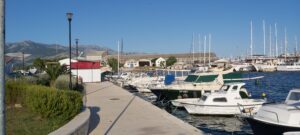
Vranjic is a small inhabited peninsula with active seafront, connected with mainland via causeway. Place is picturesque, locally often called "Small Venice". It was first inhabited, most probably, during the Late Bronze Age. Present day settlement has continuity after 1650. when new inhabitants were settled as garrison and means of defense against Turkish incursions.
Our Lady's Isle -the oldest Mariane shrine in Croatia, Gradina complex- fort-hill, Hollow church - The church is from the 11th century, linked with the coronation of Zvonimir as a Croatian king in 1075. Ancient Salona is positioned arose the bay from Vranjic.
Distance: 2 km < D < 3 km
Organisation of internal spaces (related to "final intended use"): Vranjic is made up of primarily older residential buildings with shops and other amentities in ground floor, with several public buildings and gathering spaces.
Structure and Material Characteristics: Other
State of the structure: Diverse range of materials is used, for a wide range of buildings. Older buildings are made from stone while newer are made from concrete, almost all are having wooden construction sloped roofs coverd with stone or red clay tiles.
Electrical System: Presence of a public network in the Surrounding Area, presence of connections to the public network, presence of systems in the Infrastructure/Building/Archeologic Site – (Score = 3)
Sanitary Installation: Presence of a public network in the Surrounding Area, presence of connections to the public network, presence of systems in the Infrastructure/Building/Archeologic Site – (Score = 3)
Gasworks: Total lack of systems in the Infrastructure/Building/Archeological Site, total lack of connections to the public network and absence of a public network in the surrounding area – (Score = 0)
Existing infrastructure for private mobility: Presence of a paved road that lead to the Infrastructure/Building/Archeological Site and of a parking in the surrounding area – (Score = 3)
Presence of a bicycle lane: no
Existing infrastructure for public means of transport: Easy to attain with public MoT (>500 and <1km) – (Score = 2)
The infrastructure/building/Archeological Site is considered as “Bounded Heritage”: yes
Which is the level of complexity of the administrative procedures to be adopted to manage it in terms of renovation/retrofit or Temporary Uses activation?: Complicated – (Score = 0)
Mostly under private ownership.
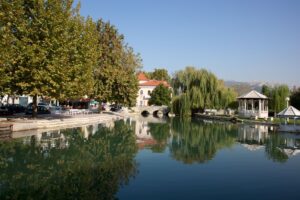
Code: HR_SO_03
Location / Address:
Date of mapping: 21/02/2020
Property tipology: Private
State of occupancy: Occupied
State of preservation: Need of minor interventions on non-structural elements - (Score = 2)
Level of practicability: Total - (Score = 1)
Surrounding area: Yes - (Score = 1)
A building under municipality management is usually used for indoor public events.
Construction era: Contemporary Era (XIX a.C. – Today)
Buried archaeological remains: Certain presence of buried Archaeological remains – (Score = 3);
Historic center of Solin is positioned on the eastern side of ancient Salona, and is also one of the most important early Medieval centers of Croatian culture. With time its importance decreased in favor of Split. Nonetheless, it has multiple importante cultural and historic sites. Also, it is presumed to be a place of other survey significant archeological sites.
Our Lady's Isle -the oldest Mariane shrine in Croatia, Gradina complex- fort-hill, Hollow church - The church is from the 11th century, linked with the coronation of Zvonimir as a Croatian king in 1075. Ancient Salona is located on the western side of the site.
Distance: D < 1 km
Organisation of internal spaces (related to "final intended use"): Historic center of Solin is made up of primarily older residential buildings with shops and other amentities in ground floor, with several public buildings and gathering spaces.
Structure and Material Characteristics: Other
State of the structure: Diverse range of materials is used, for a wide range of buildings. Older buildings are made from stone while newer are made from concrete, almost all have wooden construction sloped roofs covered with stone or red clay tiles.
Electrical System: Presence of a public network in the Surrounding Area, presence of connections to the public network, presence of systems in the Infrastructure/Building/Archeologic Site – (Score = 3)
Sanitary Installation: Presence of a public network in the Surrounding Area, presence of connections to the public network, presence of systems in the Infrastructure/Building/Archeologic Site – (Score = 3)
Gasworks: Presence of a public network in the Surrounding Area, total lack of systems in the Infrastructure/Building/Archeological Site, total lack of connections to the public network – (Score = 1)
Existing infrastructure for private mobility: Presence of a paved road that lead to the Infrastructure/Building/Archeological Site and of a parking in the surrounding area – (Score = 3)
Presence of a bicycle lane: no
Existing infrastructure for public means of transport: close to public MoT (<500 m) – (Score = 3)
The infrastructure/building/Archeological Site is considered as “Bounded Heritage”: yes
Which is the level of complexity of the administrative procedures to be adopted to manage it in terms of renovation/retrofit or Temporary Uses activation?: Complicated – (Score = 0)
Mostly under private ownership.
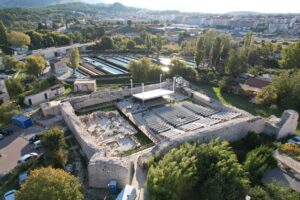
Code: HR_SO_02
Location / Address: Ul. kralja Zvonimira bb, 21210, Solin, Croatia
Date of mapping: 08/11/2019
Property tipology: Public
State of occupancy: Abandoned
State of preservation: Ruin - (Score = 0)
Level of practicability: Total - (Score = 1)
Surrounding area: Yes - (Score = 1)
It is possible to organise public events in part of the archeologic site in safe conditions. It is suitable for public events in the open space.
Construction era: Medieval Era (VIII - XIV a.C.)
Buried archaeological remains: Certain presence of buried Archaeological remains – (Score = 3);
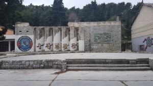
Among the remains of the Solin buildings, of particular interest is the complex known as Gradina (Hill-Fort), next to the very river and the Roman town’s eastern walls. A church of an unusual ground plan, built over the Roman époque remains, is today situated within a medieval fortress. This was built, according to some authors (F. Bulić and Lj. Karaman), by the Split archbishop Ugolino de Mala Branca (1349-1388) to protect the people of Split from the people of Klis. Today, it is in a fortress built during the Venetian-Turkish wars, in the 16th century (<). It was researched in 1909-1911 and again in 1923-1925, its ground plan and volume have recently been presented in drawings by J. Marasović, which is a convincing reconstruction. The church was for the first time correctly dated to the time of the Byzantine emperor Justinian (527-567) by M. Prelog, some fifty years ago.
Our Lady's Isle -the oldest Mariane shrine in Croatia, Archaelogical park of Salona, Hollow church - The church is from the 11th century, linked with the coronation of Zvonimir as a Croatian king in 1075.
Distance: D < 1 km
Organisation of internal spaces (related to "final intended use"): The Gradina is currently used as an open summer stage. It was originally a medieval fortress, and later a church was built in it.
Structure and Material Characteristics: Bearing Masonry
State of the structure: Gradina is in ruins.
Electrical System: Presence of a public network in the Surrounding Area, presence of connections to the public network, total lack systems in the Infrastructure/Building/Archeological Site – (Score = 2)
Sanitary Installation: Presence of a public network in the Surrounding Area, total lack of systems in the Infrastructure/Building/Archeological Site, total lack of connections to the public network – (Score = 1)
Gasworks: Total lack of systems in the Infrastructure/Building/Archeological Site, total lack of connections to the public network and absence of a public network in the surrounding area – (Score = 0)
Existing infrastructure for private mobility: Presence of a paved road that lead to the Infrastructure/Building/Archeological Site and of a parking in the surrounding area – (Score = 3)
Presence of a bicycle lane: no
Existing infrastructure for public means of transport: close to public MoT (<500 m) – (Score = 3)
The infrastructure/building/Archeological Site is considered as “Bounded Heritage”: yes
Which is the level of complexity of the administrative procedures to be adopted to manage it in terms of renovation/retrofit or Temporary Uses activation?: Complicated – (Score = 0)
The archaelogical Part is managed by the Archaelogical museum in Split, it is located in Solin and it is partialy privately owned. We are in the process of making a new management plan if the site.
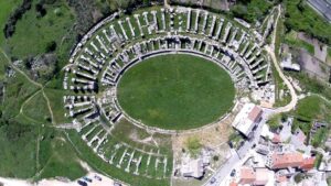
Code: HR_SO_01
Location / Address: Don Frane Bulića 91, Manastirine, 21210 Solin
Date of mapping: 05/02/2023
Property tipology: Private
State of occupancy: Partly Occupied
State of preservation: Ruin - (Score = 0)
Level of practicability: Partial - (Score = 0.5)
Surrounding area: Yes - (Score = 1)
It is possible to organise public events in part of the archeologic site in safe conditions. The park is partialy public, and partialy privatly owned. It is suitable for public events in the open space since the park consists of roman ruins. Private owned parts can't be used, but public space is large enough to host events.
Construction era: Late Antique Era (IV - VII a.C.)
Buried archaeological remains: Certain presence of buried Archaeological remains – (Score = 3);
Ancient Salona was the capital of the Roman province of Dalmatia. Its favorable geographic position allowed a quick development of the town into a prosperous city. The most impressive Salonitan structure - the amphitheatre - was erected in the second half of the 2nd century, along with the public baths and an aqueduct. A particularly significant period in the city's history was the reign of Emperor Diocletian, during whose rule a great number of splendid buildings were erected, the forum, temples, thermae and an annex to the amphitheatre. The most glorious period in the Salonitan history began with the Milan Edict of 313 A.D., allowing free practice of the Christian faith. A powerful Christian community developed and numerous churches were built. The invasions of the Avars and Slavs in the early 7th century marked the end of Salona forcing the residents to flee to the off-shore islands or the nearby Diocletian's Palace which later developed into the nucleus of Split in the Middle Ages.
Our Lady's Isle -the oldest Mariane shrine in Croatia, Gradina complex- fort-hill, Hollow church - The church is from the 11th century, linked with the coronation of Zvonimir as a Croatian king in 1075.
Distance: D < 1 km
Organisation of internal spaces (related to "final intended use"): The archaeological park is a network of walkways connecting archaeological ruins. Different outdoor manifestations are regularly held. Additionally, there is a reception building which features archaeological exhibits.
Structure and Material Characteristics: Bearing Masonry
State of the structure: The archeological park is in ruins.
Electrical System: Presence of a public network in the Surrounding Area, presence of connections to the public network, presence of systems in the Infrastructure/Building/Archeologic Site – (Score = 3)
Sanitary Installation: Presence of a public network in the Surrounding Area, presence of connections to the public network, presence of systems in the Infrastructure/Building/Archeologic Site – (Score = 3)
Gasworks: Presence of a public network in the Surrounding Area, total lack of systems in the Infrastructure/Building/Archeological Site, total lack of connections to the public network – (Score = 1)
Existing infrastructure for private mobility: Presence of a paved road that lead to the Infrastructure/Building/Archeological Site and of a parking in the surrounding area – (Score = 3)
Presence of a bicycle lane: no
Existing infrastructure for public means of transport: close to public MoT (<500 m) – (Score = 3)
The infrastructure/building/Archeological Site is considered as “Bounded Heritage”: yes
Which is the level of complexity of the administrative procedures to be adopted to manage it in terms of renovation/retrofit or Temporary Uses activation?: Complicated – (Score = 0)
The archaeological Part is managed by the Archaeological museum in Split, it is located in Solin and it is partially privately owned. We are in the process of making a new management plan if the site.
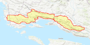
Code: HR1000027
Name of element: Mosor, Kozjak i Trogirska zagora
Date of the protection act:: 01/07/2013
Motivation of the protection: Xeric rocky area with cliffs suitable for breeding of birds of prey. Open habitats and mosaics are one of the most important nesting area of Olive-tree Warbler in Croatia. Forest habitats are represented by young submediterranean forests and scrubs. Lithostratigraphic units represented in this area are: rudist limestones (cenomanian-maastricht - K21-6), limestone and dolomite (lower cretaceous - K1), flysch sediments (middle and upper eocene - E2, 3), limestones and dolomites (upper jurassic - J3). Soils: shallow and medium deep terra rossa, brown soil on limestone, limestone and dolomite black soil, rocky ground. Mountain massifs Kozjak and Mosor were formed by Alpine orogenesis; many speleological objects and other karst formations; this area has a complex structure of morphogenetic types of relief and complex orographic structure as a result of dynamic geotectonic relations, hydrogeological conditions, climate and anthropogenic influences.
Information on birds population sizes was provided by the Institute for Ornithology. Numbers presented refer to estimations or exact data based as much as possible on recent surveys (data provided by the Institute staff and their field-work associates) - SPA Mosor, Kozjak i Trogirska zagora is especially important for breeding birds of prey. It holds 8% of national population of Aquila chrysaetos, 7,5% of Falco peregirnus and 3,7% of Circaetus gallicus. Falco biarmicus was registered in the area but breeding was not confirmed. SPA Mosor, Kozjak i Trogirska zagora is one of the two most important breeding sites for Hippolais olivetorum in Croatia, holding 8% of national population.
Level of identification of the area as heritage by the community: Community is partially or poorly aware of the sites importance as the natural heritage.
Historical value: preserved
Historical value motivation: None.
Cultural value: preserved
Cultural value motivation: None.
Natural value: preserved
Natural value motivation: SPA Mosor, Kozjak i Trogirska zagora is especially important for breeding birds of prey. It holds 8% of national population of Aquila chrysaetos, 7,5% of Falco peregirnus and 3,7% of Circaetus gallicus. Falco biarmicus was registered in the area but breeding was not confirmed. SPA Mosor, Kozjak i Trogirska zagora is one of the two most important breeding sites for Hippolais olivetorum in Croatia, holding 8% of national population.
Morphological value: preserved
Morphological value motivation:
Aesthetic value: preserved
Aesthetic value motivation: None.
Institution/Body in charge of the management of the site: Croatian Agency for the Environment and Nature.
Main Cultural/Touristic points of interest within the site: Part of the site is Excursion site Majdan at the the source of the river Jadro. It is a favorite excursion site for the citizens of Solin and surrounding area.
Is it possible to visit the site?: yes
Accessibility with reference to existing infrastructures in the Surrounding area for private mobility (car, bicycles, etc.):: Presence of a paved road that lead to the Infrastructure/Building/Archeological Site, absence of a parking
Presence of a bicycle lane: no
Accessibility with reference to existing infrastructures for public means of transport - MoT (collective transport: bus, train, etc.): Difficult to attain public MoT (>1 and <3 km)
Time of the survey: 01/11/2019
Click on the marker on the map to get more info about the cultural or natural heritage point of interest.
The aim of the mapping is to evaluate the convenience to regenerate/reactivate a Site through Temporary Uses (TUs).