Myportheritage
Menu
This pilot action will be developed in synergy with the ECC2020 Programme lines. It will be hosted by:
Take a look at the TEMPUS – Final Exhibition.
Pilot storytelling Virtual exhibitionCode: HR_RI_20
Location / Address: Ulica Milutina Barača 26, 51000 Rijeka
Date of mapping: 13/07/2020
Property tipology: Private
State of occupancy: Occupied
State of preservation: Need of minor interventions on non-structural elements - (Score = 2)
Level of practicability: Partial - (Score = 0.5)
Surrounding area: Yes - (Score = 1)
Limited possibility to organise public events due to safety concerns and private ownership of the site.
Construction era: Contemporary Era (XIX a.C. – Today)
Buried archaeological remains: Low probability (based on the available Archaeological information) – (Score = 1);
It was founded in 1882 as part of the Pest Oil Refinery from Pest and began its work in 1883. Milutin Barač was elected technical director and successfully led the refinery until the end of the First World War. The first products of the refinery were kerosene, paraffin, various solvents, resin, coke and gasoline. At the time, oil was imported in barrels from the United States, and from 1890 from Russia and Galicia. After the end of the First World War, the nearby rice processing plant ceased to operate, and the refinery became the property of the Joint Stock Company of the Mineral Oil Refinery (ROMSA). In 1939, Eneo Perugini renovated the former administrative building of the rice husk in the wake of Italian neorealism. The administrative building is still in operation today and has retained its original appearance. After the end of the Second World War, the factory changed its name to the Rijeka Refinery, then was named Boris Kindrič, and in the 1960s it became part of INA.
Nearest Cultural/Touristic point of Interest are Museum of Modern and Contemporary Art and City Museum of Rijeka which are situated aprx. 1 km away.
Distance: 1 km < D < 2 km
Organisation of internal spaces (related to "final intended use"): A vast complex of buildings.
Structure and Material Characteristics: Reinforced Concrete frame structure
State of the structure: Mostly in good condition and well preserved.
Electrical System: Presence of a public network in the Surrounding Area, presence of connections to the public network, presence of systems in the Infrastructure/Building/Archeologic Site – (Score = 3)
Sanitary Installation: Presence of a public network in the Surrounding Area, presence of connections to the public network, presence of systems in the Infrastructure/Building/Archeologic Site – (Score = 3)
Gasworks: Presence of a public network in the Surrounding Area, presence of connections to the public network, presence of systems in the Infrastructure/Building/Archeologic Site – (Score = 3)
Existing infrastructure for private mobility: Presence of a paved road that lead to the Infrastructure/Building/Archeological Site and of a parking in the surrounding area – (Score = 3)
Presence of a bicycle lane: no
Existing infrastructure for public means of transport: close to public MoT (<500 m) – (Score = 3)
The infrastructure/building/Archeological Site is considered as “Bounded Heritage”: no
Which is the level of complexity of the administrative procedures to be adopted to manage it in terms of renovation/retrofit or Temporary Uses activation?: Complicated – (Score = 0)
Privately owned by oil company INA.
Code: HR_RI_02
Location / Address: Ulica Milutina Barača 19
Date of mapping: 06/11/2019
Property tipology: Private
State of occupancy: Partly Occupied
State of preservation: Need of interventions on structural framework - (Score = 1)
Level of practicability: Partial - (Score = 0.5)
Surrounding area: Yes - (Score = 1)
There is possibility of open-air events and smaller indoor events at the rennovated Porin building, Proizvodni park Torpedo, (former Factory hall no. 14) which is part of the complex.
Construction era: Contemporary Era (XIX a.C. – Today)
Buried archaeological remains: Low probability (based on the available Archaeological information) – (Score = 1);
Industrial complex of the first torpedo factory in the world. The first torpedo was made in 1866. and through it Rijeka found its place at the top of the global industrial innovation and production of the time. As for the preserved architectural spaces of the factory, we should mention Villa Whitehead as the most representative administration building of the company, the hall complex with production facilities, the warehouses made of reinforced concrete as well as the launching pad itself. All the projects were designed by renowned architects Giacomo Zammatio, Giovanni Maria Curet and others. The factory, although in substantially altered form, continued to exist until the 1990s. The last torpedo was produced in 1966, after which the plant started producing diesel engines and tractors.
All the main sights of Rijeka are within the radius of 2km.
Distance: 1 km < D < 2 km
Organisation of internal spaces (related to "final intended use"):
Structure and Material Characteristics: Reinforced Concrete frame structure
State of the structure: Structure in need of both structural and non-structural interventions.
Electrical System: Presence of a public network in the Surrounding Area, presence of connections to the public network, presence of systems in the Infrastructure/Building/Archeologic Site – (Score = 3)
Sanitary Installation: Presence of a public network in the Surrounding Area, presence of connections to the public network, presence of systems in the Infrastructure/Building/Archeologic Site – (Score = 3)
Gasworks: Presence of a public network in the Surrounding Area, presence of connections to the public network, presence of systems in the Infrastructure/Building/Archeologic Site – (Score = 3)
Existing infrastructure for private mobility: Presence of a paved road that lead to the Infrastructure/Building/Archeological Site and of a parking in the surrounding area – (Score = 3)
Presence of a bicycle lane: yes
Existing infrastructure for public means of transport: close to public MoT (<500 m) – (Score = 3)
The infrastructure/building/Archeological Site is considered as “Bounded Heritage”: no
Which is the level of complexity of the administrative procedures to be adopted to manage it in terms of renovation/retrofit or Temporary Uses activation?: Complicated – (Score = 0)
Multiple owners, parts are privately owned, parts are owned by the Port and City of Rijeka.
Code: HR_RI_05
Location / Address: Ulica Milutina Barača 3, Rijeka
Date of mapping: 20/02/2020
Property tipology: Public
State of occupancy: Occupied
State of preservation: Well preserved (no need of intervention) - (Score = 3)
Level of practicability: Total - (Score = 1)
Surrounding area: Yes - (Score = 1)
Possible to organize small-scale events on the premises.
Construction era: Contemporary Era (XIX a.C. – Today)
Buried archaeological remains: Absence of buried Archaeological remains or absence of Archaeological information about the site – (Score = 0);
In 1884, an iron lighthouse was set up at the end the breakwater of Rijeka’s port (formerly breakwater of Maria Theresa). Due to the subsidence of the breakwater, the lighthouse was moved to Mlaka at the end of the 19th century. However, in 1933, it was moved for the third time and this time it was built as a four-storey lighthouse building as well as strengthened with reinforced concrete. The last change occurred in 2002, when the building gained another floor for the Coastal Radio Station. The light is visible from a distance of approximately 33 kilometres or 17.8 nautical miles. Today, the lighthouse is fully automated and an integral part of the cityscape. The lighthouse is now harder visible from the sea becouse it is surrounded by buildings and city lights.
It is possible to visit the lighthouse, which offers a view of the harbour warehouses, the railway and the docks. All the main sights of Rijeka are within a 2km radius.
Distance: 1 km < D < 2 km
Organisation of internal spaces (related to "final intended use"): The last change occurred in 2002, when the building gained another floor for the Coastal Radio Station.
Structure and Material Characteristics: Reinforced Concrete frame structure
State of the structure: Well preserved.
Electrical System: Presence of a public network in the Surrounding Area, presence of connections to the public network, presence of systems in the Infrastructure/Building/Archeologic Site – (Score = 3)
Sanitary Installation: Presence of a public network in the Surrounding Area, presence of connections to the public network, presence of systems in the Infrastructure/Building/Archeologic Site – (Score = 3)
Gasworks: Presence of a public network in the Surrounding Area, presence of connections to the public network, presence of systems in the Infrastructure/Building/Archeologic Site – (Score = 3)
Existing infrastructure for private mobility: Presence of a paved road that lead to the Infrastructure/Building/Archeological Site and of a parking in the surrounding area – (Score = 3)
Presence of a bicycle lane: yes
Existing infrastructure for public means of transport: close to public MoT (<500 m) – (Score = 3)
The infrastructure/building/Archeological Site is considered as “Bounded Heritage”: no
Which is the level of complexity of the administrative procedures to be adopted to manage it in terms of renovation/retrofit or Temporary Uses activation?: Ordinary – (Score = 1)
The lighthouse is owned by Plovput, a state-owned company.
Code: HR_RI_07
Location / Address: Ružićeva ulica 5, Rijeka
Date of mapping: 12/02/2020
Property tipology: Public
State of occupancy: Occupied
State of preservation: Well preserved (no need of intervention) - (Score = 3)
Level of practicability: Partial - (Score = 0.5)
Surrounding area: No - (Score = 0)
The building and its surroundings are not suitable for the organization of public events.
Construction era: Roman Era (III b.C. - III a.C.)
Buried archaeological remains: Absence of buried Archaeological remains or absence of Archaeological information about the site – (Score = 0);
The building had several different uses. It was built as a hotel in the Art Nouveau style between the two wars. Afterwards, it became the seat of the biggest shipping company in the Kingdom of Serbs, Croats, and Slovenes. After World War II it served as the branch of Yugoslav Academy of Sciences and Arts and after Croatia gained its independence it became the branch of Croatian Academy of Sciences and Arts . The building is at the beginning of the street leading to Rijeka's most important industrial plants in the early 20th century. It is also close to the Trsat stairs, the beginning of which is marked by a plaque commemorating the relics of Croatian hero Petar Kružić in the fight against the Ottomans. The first railway bridge in the city of Rijeka was erected nearby, as well as one of the oldest hotels in the city that are still in function, Hotel Continental.
Trsat Castle, Croatian National Theatre, Peek & Poke Museum, Natural History Museum, Maritime and History Museum of the Croatian Littoral (Governer's Palace), Church of the Assumption of the Blessed Virgin Mary and the Leaning Tower, St. Vitus Cathedral and many more touristic landmarks are within 1 km radius.
Distance: D < 1 km
Organisation of internal spaces (related to "final intended use"):
Structure and Material Characteristics: Bearing Masonry
State of the structure: In need of non-structural interventions.
Electrical System: Total lack of systems in the Infrastructure/Building/Archeological Site, total lack of connections to the public network and absence of a public network in the surrounding area – (Score = 0)
Sanitary Installation: Total lack of systems in the Infrastructure/Building/Archeological Site, total lack of connections to the public network and absence of a public network in the surrounding area – (Score = 0)
Gasworks: Total lack of systems in the Infrastructure/Building/Archeological Site, total lack of connections to the public network and absence of a public network in the surrounding area – (Score = 0)
Existing infrastructure for private mobility: Total lack of roads and parkings that lead to the Infrastructure/Building/Archeological Site – (Score = 0)
Presence of a bicycle lane: no
Existing infrastructure for public means of transport: Unattainable with public MoT (>3km) – (Score = 0)
The infrastructure/building/Archeological Site is considered as “Bounded Heritage”: no
Which is the level of complexity of the administrative procedures to be adopted to manage it in terms of renovation/retrofit or Temporary Uses activation?: Facilitated – (Score = 2)
Code: HR_RI_01
Location / Address: Kantrida, Portić
Date of mapping: 06/11/2019
Property tipology: Public
State of occupancy: Occupied
State of preservation: Need of minor interventions on non-structural elements - (Score = 2)
Level of practicability: Total - (Score = 1)
Surrounding area: Yes - (Score = 1)
Suitable for smaller open-air public events. There is a large parking lot right next to it, and a 100 m away there is FC Rijeka's old Kantrida Stadium.
Construction era: Contemporary Era (XIX a.C. – Today)
Buried archaeological remains: Absence of buried Archaeological remains or absence of Archaeological information about the site – (Score = 0);
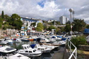
Small port near the city centre right next to football stadium Kantrida. It lacks great architectural or artistic value, but it represents living Mediterranean maritime culture and intangible heritage. It still serves its original purpose for the local community through the recreational fishing club SRD KANTRIDA. It has a mole and a lot of colourful wooden magazines still used by the local community. It is in close vicinity of FC Rijeka's old Kantrida Stadium, famous for its stands carved into the rocks.
All the main sights of Rijeka are within the radius of 3km easily reachable by public transport. In close vicinity there are indoor and outdoor swimming pools.
Distance: 2 km < D < 3 km
Organisation of internal spaces (related to "final intended use"): Small traditional mediterranean port with a mole and a lot of wooden magazines still used by the local community.
Structure and Material Characteristics: Bearing Masonry
State of the structure: Well preserved. Still in its original function.
Electrical System: Presence of a public network in the Surrounding Area, presence of connections to the public network, presence of systems in the Infrastructure/Building/Archeologic Site – (Score = 3)
Sanitary Installation: Presence of a public network in the Surrounding Area, presence of connections to the public network, presence of systems in the Infrastructure/Building/Archeologic Site – (Score = 3)
Gasworks: Presence of a public network in the Surrounding Area, presence of connections to the public network, presence of systems in the Infrastructure/Building/Archeologic Site – (Score = 3)
Existing infrastructure for private mobility: Presence of a paved road that lead to the Infrastructure/Building/Archeological Site and of a parking in the surrounding area – (Score = 3)
Presence of a bicycle lane: no
Existing infrastructure for public means of transport: close to public MoT (<500 m) – (Score = 3)
The infrastructure/building/Archeological Site is considered as “Bounded Heritage”: no
Which is the level of complexity of the administrative procedures to be adopted to manage it in terms of renovation/retrofit or Temporary Uses activation?: Ordinary – (Score = 1)
Permissions needed from Port Authority, Primorje-Gorski Kotar County and City of Rijeka.
Code: HR_RI_03
Location / Address: Titov trg bb, Rijeka
Date of mapping: 12/02/2020
Property tipology: Public
State of occupancy: Occupied
State of preservation: Well preserved (no need of intervention) - (Score = 3)
Level of practicability: Total - (Score = 1)
Surrounding area: Yes - (Score = 1)
Suitable for open-air events because the Chapel is situated in a large square in the city centre.
Construction era: Modern Era (XV – XVIII a.C.)
Buried archaeological remains: Absence of buried Archaeological remains or absence of Archaeological information about the site – (Score = 0);
This building has a continuity of over 300 years. It has an octagonal floor plan and it was built by the Jesuits in 1717. The border between the Kingdom of Italy and the Kingdom of Yugoslavia between two world wars passed right through the Chapel which served as a communication point for citizens on both sides of the border. After the War Destruction and the Liberation of Rijeka in 1945, the construction of the demolished bridge and square began and the chapel was removed in 1954. Today there is a recostruction of the chapel but it has no religous purpose and it has no walls, but bearing columns. The statue of St. John Nepomuk which used to be in the chapel is now on display in the Church of the Assumption of the Blessed Virgin Mary a couple of hundred meters away.
Croatian National Theatre, Peek & Poke Museum, Natural History Museum, Maritime and History Museum of the Croatian Littoral (Governer's Palace), Church of the Assumption of the Blessed Virgin Mary and the Leaning Tower, St. Vitus Cathedral and many more touristic landmarks are within 1 km radius.
Distance: D < 1 km
Organisation of internal spaces (related to "final intended use"):
Structure and Material Characteristics: Bearing Masonry
State of the structure: A reconstruction of the the original structure.
Electrical System: Presence of a public network in the Surrounding Area, presence of connections to the public network, presence of systems in the Infrastructure/Building/Archeologic Site – (Score = 3)
Sanitary Installation: Presence of a public network in the Surrounding Area, total lack of systems in the Infrastructure/Building/Archeological Site, total lack of connections to the public network – (Score = 1)
Gasworks: Presence of a public network in the Surrounding Area, total lack of systems in the Infrastructure/Building/Archeological Site, total lack of connections to the public network – (Score = 1)
Existing infrastructure for private mobility: Presence of a paved road that lead to the Infrastructure/Building/Archeological Site and of a parking in the surrounding area – (Score = 3)
Presence of a bicycle lane: no
Existing infrastructure for public means of transport: close to public MoT (<500 m) – (Score = 3)
The infrastructure/building/Archeological Site is considered as “Bounded Heritage”: no
Which is the level of complexity of the administrative procedures to be adopted to manage it in terms of renovation/retrofit or Temporary Uses activation?: Ordinary – (Score = 1)
Permits needed from the municipal authority.
Code: HR_RI_11
Location / Address: Ulica Milutina Barača 7, Rijeka
Date of mapping: 20/02/2020
Property tipology: Private
State of occupancy: Partly Occupied
State of preservation: Need of interventions on structural framework - (Score = 1)
Level of practicability: Partial - (Score = 0.5)
Surrounding area: No - (Score = 0)
Not suitable for events at the moment.
Construction era: Contemporary Era (XIX a.C. – Today)
Buried archaeological remains: Low probability (based on the available Archaeological information) – (Score = 1);
At the beginning of the 20th century, with the development of the passenger port and the intensification of transatlantic routes to America, Rijeka became a centre of migratory movements of the population. Passenger capacities were insufficient, so the Hungarian Ministry of the Interior decided to build a new hotel. The project of the Hotel Emigranti was made by engineer Szilárd Zielinski, a professor at the Polytechnic Institute of the Budapest University. It is an approximately 160 meters long building with a ground floor and two storeys, located in the former Industrijska Street, opposite the Rice Mill. The same location was chosen because of the proximity to the port and railway pier. The building of the former Hotel Emigranti exists even today. In the 1920s, it was used as a trade fair area and, after World War II, as an industrial facility. In 1953, the packaging factory of 8. Mart, later known as the Metallographic Combine, was placed in the area of the former hotel.
Nearest Cultural/Touristic point of Interest is Museum of Modern and Contemporary Art which is situated aproximately 1km away.
Distance: 1 km < D < 2 km
Organisation of internal spaces (related to "final intended use"):
Structure and Material Characteristics: Reinforced Concrete frame structure
State of the structure: Need of total refurbishment and interventions on the structure itself.
Electrical System: Presence of a public network in the Surrounding Area, presence of connections to the public network, presence of systems in the Infrastructure/Building/Archeologic Site – (Score = 3)
Sanitary Installation: Presence of a public network in the Surrounding Area, presence of connections to the public network, presence of systems in the Infrastructure/Building/Archeologic Site – (Score = 3)
Gasworks: Presence of a public network in the Surrounding Area, presence of connections to the public network, presence of systems in the Infrastructure/Building/Archeologic Site – (Score = 3)
Existing infrastructure for private mobility: Presence of a paved road that lead to the Infrastructure/Building/Archeological Site and of a parking in the surrounding area – (Score = 3)
Presence of a bicycle lane: no
Existing infrastructure for public means of transport: close to public MoT (<500 m) – (Score = 3)
The infrastructure/building/Archeological Site is considered as “Bounded Heritage”: no
Which is the level of complexity of the administrative procedures to be adopted to manage it in terms of renovation/retrofit or Temporary Uses activation?: Complicated – (Score = 0)
Code: HR_RI_14
Location / Address: The Port of Rijeka, Žabica 6
Date of mapping: 12/02/2020
Property tipology: Public
State of occupancy: Occupied
State of preservation: Need of interventions on structural framework - (Score = 1)
Level of practicability: Partial - (Score = 0.5)
Surrounding area: Yes - (Score = 1)
Abundance of outdoor and indoor spaces but for now mostly not suitable for events because it's still used by the Port Authority.
Construction era: Contemporary Era (XIX a.C. – Today)
Buried archaeological remains: Absence of buried Archaeological remains or absence of Archaeological information about the site – (Score = 0);
After the Austro-Hungarian Compromise of 1867, Hungary made efforts to make Rijeka a major export port which demanded the investment of significant resources in the construction of railways. In parallel with the construction of the railroad, railway warehouses were erected stretching from the Žabica square to Brgud (today’s 3. Maj Shipyard), with the intention of transhipment and storage of goods. By the end of the 19th century, thirty warehouses were built, both open and permanent storage warehouses, with clear historicist stylistic characteristics. The warehouses number IIIa, IIIb and 15 (today warehouses no. 31, 32, 33) are still standing today. Those warehouses are early examples of use of renforced concrete. Warehouse no. 17 was built on the former Mary Valerius Pier, known today as Visin Pier. The construction took place between 1906 and 1909. It was the first warehouse in Rijeka with a structure consisting entirely of reinforced concrete.
All major Rijeka landmarks are within 2 km radius.
Distance: 1 km < D < 2 km
Organisation of internal spaces (related to "final intended use"):
Structure and Material Characteristics: Reinforced Concrete frame structure
State of the structure:
Electrical System: Presence of a public network in the Surrounding Area, presence of connections to the public network, presence of systems in the Infrastructure/Building/Archeologic Site – (Score = 3)
Sanitary Installation: Presence of a public network in the Surrounding Area, presence of connections to the public network, presence of systems in the Infrastructure/Building/Archeologic Site – (Score = 3)
Gasworks: Presence of a public network in the Surrounding Area, presence of connections to the public network, presence of systems in the Infrastructure/Building/Archeologic Site – (Score = 3)
Existing infrastructure for private mobility: Presence of a paved road that lead to the Infrastructure/Building/Archeological Site and of a parking in the surrounding area – (Score = 3)
Presence of a bicycle lane: no
Existing infrastructure for public means of transport: Unattainable with public MoT (>3km) – (Score = 0)
The infrastructure/building/Archeological Site is considered as “Bounded Heritage”: no
Which is the level of complexity of the administrative procedures to be adopted to manage it in terms of renovation/retrofit or Temporary Uses activation?: Complicated – (Score = 0)
Need of permits from various local and national bodies.
Code: HR_RI_04
Location / Address: Fiumara bb, Rijeka
Date of mapping: 20/02/2020
Property tipology: Public
State of occupancy: Occupied
State of preservation: Need of minor interventions on non-structural elements - (Score = 2)
Level of practicability: Partial - (Score = 0.5)
Surrounding area: Yes - (Score = 1)
Suitable for open-air public events.
Construction era: Modern Era (XV – XVIII a.C.)
Buried archaeological remains: Low probability (based on the available Archaeological information) – (Score = 1);
The Dead Canal was a stream of river Rječina until 1855 when a new canal was dug nearby to prevent the flooding of the city. Since then, the sea has been released into the canal which was used for trade and as a port for sailboats and smaller vessels. It lost its port function after 1945 when it gradually became a port for small fishing boats, which remains to this day.
Croatian National Theatre, Peek & Poke Museum, Natural History Museum, Maritime and History Museum of the Croatian Littoral (Governor's Palace), Church of the Assumption of the Blessed Virgin Mary and the Leaning Tower, St. Vitus Cathedral and many more tourist landmarks are within 1 km radius.
Distance: D < 1 km
Organisation of internal spaces (related to "final intended use"):
Structure and Material Characteristics: Bearing Masonry
State of the structure: Well preserved.
Electrical System: Presence of a public network in the Surrounding Area, presence of connections to the public network, presence of systems in the Infrastructure/Building/Archeologic Site – (Score = 3)
Sanitary Installation: Presence of a public network in the Surrounding Area, presence of connections to the public network, presence of systems in the Infrastructure/Building/Archeologic Site – (Score = 3)
Gasworks: Total lack of systems in the Infrastructure/Building/Archeological Site, total lack of connections to the public network and absence of a public network in the surrounding area – (Score = 0)
Existing infrastructure for private mobility: Presence of a paved road that lead to the Infrastructure/Building/Archeological Site and of a parking in the surrounding area – (Score = 3)
Presence of a bicycle lane: no
Existing infrastructure for public means of transport: close to public MoT (<500 m) – (Score = 3)
The infrastructure/building/Archeological Site is considered as “Bounded Heritage”: no
Which is the level of complexity of the administrative procedures to be adopted to manage it in terms of renovation/retrofit or Temporary Uses activation?: Ordinary – (Score = 1)
Code: HR_RI_06
Location / Address: Senjsko pristanište, Brajdica, Rijeka
Date of mapping: 12/02/2020
Property tipology: Public
State of occupancy: Occupied
State of preservation: Well preserved (no need of intervention) - (Score = 3)
Level of practicability: Total - (Score = 1)
Surrounding area: Yes - (Score = 1)
Possible to organize open-air events. Today, the Sušak basin is part of the port of Rijeka for bulk cargo. There is a new container terminal nearby. Next to the harbour is a new passenger terminal.
Construction era: Contemporary Era (XIX a.C. – Today)
Buried archaeological remains: Low probability (based on the available Archaeological information) – (Score = 1);
The construction of the Baross harbour (Sušak basin) began and was completed in 1894, intended mainly for timber traffic. It is built as a smaller pool completely enclosed by a breakwater 420 m long and connected to the Dead Channel on the north side. It had 11 cranes and 163,000 square feet of open warehouses on the embankments of Delta and Brajda. Porto Baross has been developing continuously from 1894 to the present, through three different countries, the Austro-Hungarian Monarchy, the Kingdom and Socialist Yugoslavia, even today when it operates in the Republic of Croatia.
Croatian National Theatre, Peek & Poke Museum, Natural History Museum, Maritime and History Museum of the Croatian Littoral (Governer's Palace), Church of the Assumption of the Blessed Virgin Mary and the Leaning Tower, St. Vitus Cathedral and many more touristic landmarks are within 1 km radius.
Distance: D < 1 km
Organisation of internal spaces (related to "final intended use"):
Structure and Material Characteristics: Bearing Masonry
State of the structure: Well preserved.
Electrical System: Presence of a public network in the Surrounding Area, presence of connections to the public network, presence of systems in the Infrastructure/Building/Archeologic Site – (Score = 3)
Sanitary Installation: Presence of a public network in the Surrounding Area, presence of connections to the public network, presence of systems in the Infrastructure/Building/Archeologic Site – (Score = 3)
Gasworks: Presence of a public network in the Surrounding Area, presence of connections to the public network, total lack systems in the Infrastructure/Building/Archeological Site – (Score = 2)
Existing infrastructure for private mobility: Presence of a paved road that lead to the Infrastructure/Building/Archeological Site and of a parking in the surrounding area – (Score = 3)
Presence of a bicycle lane: no
Existing infrastructure for public means of transport: close to public MoT (<500 m) – (Score = 3)
The infrastructure/building/Archeological Site is considered as “Bounded Heritage”: no
Which is the level of complexity of the administrative procedures to be adopted to manage it in terms of renovation/retrofit or Temporary Uses activation?: Ordinary – (Score = 1)
Click on the marker on the map to get more info about the cultural or natural heritage point of interest.
The aim of the mapping is to evaluate the convenience to regenerate/reactivate a Site through Temporary Uses (TUs).