Myportheritage
Menu
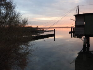
This Pilot action will be the first trigger action involving the regeneration of a dismissed area on the left-side of the Candiano Channel, in the Darsena of Ravenna. This action foresees the creation of a Temporary-Use infrastructure made of containers, which shall host business/ organisations related to the port’s heritage valorization.
Pilot storytelling Virtual exhibition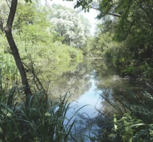
Code: IT4070001
Name of element: Punte Alberete, Valle Mandriole
Date of the protection act:: 01/10/1988
Motivation of the protection: The southern part, Punte Alberete (about 190 ha), is a predominantly hygrophilous wood dominated by Fraxinus oxycarpa, Ulmus minor, Populus alba, Salix alba; the northern part, Valle Mandriole (about 240 ha), is an open valley, also in the process of being partially filled with abundant helophytic populations. Both freshwater wetlands are characterized by the alternation of different micro-environments and plant formations in relation to the depth and seasonal variations of water levels. RARE and THREATENED plant species: Leucojum aestivum, Sagittaria sagittifolia. VERY RARE and Endangered: Utricularia australis, Oenanthe fistulosa. Animal species: Chamaesphecia palustris: species linked to marsh habitats, of which Punte Alberete and the neighboring Bardello constitute the only Italian station. Paradromius longiceps: localized species, linked to fragmiteti, especially in coastal areas. Dicranthus majzlani: relict population, linked to fragmiteti. Very important heronry with the only Italian population of Phalacrocorax pygmaeus, also Phalacrocorax carbo sinensis, Plegadis falcinellus (irr.), Platalea leucorodia (irr.) and all species of European Ardeidae. Aythya nyroca has about 50% of the Italian population here. One of the very few known regional sites of Barbastella barbastellus. One of the three regional sites of Rana latastei.
Level of identification of the area as heritage by the community: This site presents a typical natural environment for the nesting and resting place of migratory birds (palmipeds and waders), and, for the suggestive beauty of the landscape which has remained in its natural state, and, from a botanical point of view, for the conservation of the particular flora that lives under water.
Historical value: preserved
Historical value motivation:
Cultural value: preserved
Cultural value motivation:
Natural value: preserved
Natural value motivation: The anthropic pressure caused by hunting and tourism is the main threat factor that leads to the natural evolution of freshwater marsh systems towards the lowland forest, with progressive loss of aquatic ecosystems and, therefore, possible loss of natural value, which however currently remains.
Morphological value: preserved
Morphological value motivation:
Aesthetic value: preserved
Aesthetic value motivation: The aesthetic value of this site is closely connected to the natural one and above all to its link with the existing infrastructures. In fact, the presence of the Romea State Road constitutes a caesura in the environmental system and a cause of heavy direct and indirect impact on terrestrial fauna.
Institution/Body in charge of the management of the site: Regione Emilia-Romagna - Direzione Generale Ambiente, Difesa del Suolo e della Costa - Servizio Parchi e Risorse forestali.
Main Cultural/Touristic points of interest within the site:
Is it possible to visit the site?: yes
Accessibility with reference to existing infrastructures in the Surrounding area for private mobility (car, bicycles, etc.):: Presence of a paved road that lead to the Infrastructure/Building/Archeological Site and of a parking in the surrounding area
Presence of a bicycle lane: no
Accessibility with reference to existing infrastructures for public means of transport - MoT (collective transport: bus, train, etc.): close to public MoT (<500 m)
Time of the survey:
Code: IT4070003
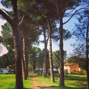
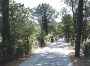
Name of element: Pineta di San Vitale, Bassa del Pirottolo
Date of the protection act:: 01/08/1988
Motivation of the protection: The pine forest of San Vitale constitutes a continuous band of greenery that extends uninterruptedly from the "La Canala" drain, narrowing in depth as one proceeds northwards, and forms a natural framework of striking beauty represented by the luxuriant pine forest of maritime pines and domestic (Pinus Pinea) from various species of oaks, oaks and holm oaks and from a dense undergrowth vegetation of brambles; The pine forest is crossed from north to south by the Bassa del Pirottolo, a depression with fresh to brackish water, and is crossed in an east-west direction by numerous canals and by the Lamone river. VERY RARE and Endangered plant species: Hottonia palustris, Centaurea spinoso-ciliata subsp. tommasinii. RARE: Helianthemum jonium. At present, the pine forest does not have any faunal interest, due to the high disturbance factors (hunting, anthropic pressure), with the exception of the presences linked to the Bassa del Pirotolo (heronry of Egretta garzetta and nesting of Himantopus himantopus). In all likelihood the Chiroptera colonies are extinct. However, it represents a unique habitat with great potential, if properly managed.
Level of identification of the area as heritage by the community: The complex of this luxuriant vegetation made up of the S. Vitale pine forest can be enjoyed as a natural beauty along the Romea road in a continuous succession of viewpoints, and is part of the historical and artistic traditions of the large pine wooded areas that characterize Ravenna.
Historical value: preserved
Historical value motivation:
Cultural value: preserved
Cultural value motivation: The cultural value of this area has been preserved over the years as it is connected to the different uses to which the stone pine was suitable. In fact, pine cultivation, which required continuous care in sowing and protecting young plants, provided the city of Ravenna with lumber, pine cones for heating, resinous essences used in perfumery and pharmacopoeia and pine nuts for food
Natural value: preserved
Natural value motivation: Rich in humid lowlands alternating with "staggi", the lowland forest on which the stone pine forest was artificially created can be divided into two main plant communities: a xerophilous forest with Quercus ilex, Phyllirea angustifolia, Ruscus aculeatus and a hygrophilous forest dominated by Populus alba, Fraxinus oxycarpa and Quercus pedunculata. The pine forest is crossed from north to south by the Bassa del Pirottolo, a depression with fresh to brackish waters, and is crossed in an east-west direction by numerous canals and by the Lamone river. The site is almost entirely included in the Po Delta Regional Park. The juxtaposition of forest and marsh environments creates natural sceneries of great charm.
Morphological value: preserved
Morphological value motivation:
Aesthetic value: preserved
Aesthetic value motivation: In these areas the aesthetics of the landscape is unique due to the various and at the same time unitary natural presences linked by human intervention which has traced the course of the rivers and created artificial canals.
Institution/Body in charge of the management of the site: Regione Emilia-Romagna - Direzione Generale Ambiente, Difesa del Suolo e della Costa - Servizio Parchi e Risorse forestali
Main Cultural/Touristic points of interest within the site: One of the points of interest in the San Vitale pine forest is undoubtedly the 2 June Park. The proximity of this park to the Ravenna riding club allows visitors to go for walks through the pine forest on the back of a horse.
Is it possible to visit the site?: yes
Accessibility with reference to existing infrastructures in the Surrounding area for private mobility (car, bicycles, etc.):: Presence of a paved road that lead to the Infrastructure/Building/Archeological Site and of a parking in the surrounding area
Presence of a bicycle lane: no
Accessibility with reference to existing infrastructures for public means of transport - MoT (collective transport: bus, train, etc.): close to public MoT (<500 m)
Time of the survey:
Code: IT4070010
Name of element: Pineta di Classe
Date of the protection act:: 22/09/2003
Motivation of the protection: Pineta di Classe is the largest pine forest located south of Ravenna. It is a lowland forest dominated by the English oak, ash, elm, white poplar, holm oak and above all by pinus pinea. There are also flooded inland lowlands and large mirrors of water (formerly gravel pits) on the western edge. With the exception of a small portion (about 7 ha), located on the West margin, the site is totally included in the Regional Park of the Po Delta. It presents 15 habitats of community interest, among which 5 priorities covering almost 80 % of site area.Presents rare and threaty vegetable species like the Lythrum hissopifolia; Animal species: Chalcides chalcides, and a rare species of forestal Chiroptera, Myotis bechsteinii. The population of Testudo hermanni appears to be in great danger due to the continuous human intervention.
Level of identification of the area as heritage by the community: The pinewood of Classe, in addition to being the largest in the south of Ravenna, was introduced by the monks of the historical abbeys (between the 10th and 15th centuries AD) to supply the city with timber. It is therefore an integral part of the history of Ravenna, as it tells the evolution of its territory. Although the anthropic interventions have radically changed the natural landscape of the coast, the collective imagination recognizes an ideal of classical beauty and harmony full of literary suggestions and historical references.
Historical value: preserved
Historical value motivation:
Cultural value: preserved
Cultural value motivation: The pinewood of Classe, in addition to having been introduced by anthropic action, over the centuries has been subjected, after the suppression of religious corporations, to a period of decline and destruction by the successive owners. During the nineteenth century due to the extension of the surrounding agricultural crops, the pine forest suffered a contraction of its area.
Natural value: preserved
Natural value motivation: Although the cultural reasons that have determined the complex physiognomy of the Classe pinewood have disappeared, its naturalistic value has remained, as confirmed by the analysis of the vegetation map that indicates an index of naturalistic value of the area with a medium / high value.
Morphological value: preserved
Morphological value motivation:
Aesthetic value: preserved
Aesthetic value motivation: The aesthetic value of the Classe pinewood appears to be preserved as, despite having been thinned out and cut over the centuries, it has not substantially lost its original conformation
Institution/Body in charge of the management of the site: Regione Emilia-Romagna - Direzione Generale Ambiente, Difesa del Suolo e della Costa - Servizio Parchi e Risorse forestali.
Main Cultural/Touristic points of interest within the site: The Primo Maggio Park extends inside the Pinewood of Classe and can be traveled on foot or by bicycle, along routes that allow you to enter the heart of the pine forest and reach the Foce del Bevano. The park has areas equipped for outdoor dining.
Is it possible to visit the site?: yes
Accessibility with reference to existing infrastructures in the Surrounding area for private mobility (car, bicycles, etc.):: Presence of a dirt road that lead to the Infrastructure/Building/Archeological Site, absence of a paved road and of a parking
Presence of a bicycle lane: yes
Accessibility with reference to existing infrastructures for public means of transport - MoT (collective transport: bus, train, etc.): Difficult to attain public MoT (>1 and <3 km)
Time of the survey:
Code: IT4070005
Name of element: Pineta di Casalborsetti, Pineta Staggioni, Duna di Porto Corsini
Date of the protection act:: 20/04/2009
Motivation of the protection: The sites mentioned extend from relict dunes covered with thermophilic scrub and with arid colonization meadows of consolidated sands, alternating with cereal crops and uncultivated land, to Pinus pinaster pine forests of anthropic origin, to active dunes, reduced to small strips by the construction of imposing artificial reefs. Also included are the beaches and the stretch of sea in front, for a stretch of about 250 metres. Also included is the mouth of the river Lamone, rectified and altered, to separate the area of Casalborsetti to the north from that of Marina Romea to the south. The site falls entirely within the Po Delta Regional Park, Pinewood station of San Vitale and Pialasse di Ravenna, for 216 ha in park areas B and C which, for the most part (207 ha) are also a State Nature Reserve (Pineta di Ravenna, contrada Staggioni and dune of Porto Corsini); for 172 hectares in the pre-park area. The hydrogeological constraint extends for 322 ha (S. Vitale area). VERY RARE and Endangered plant species: Trachomitum venetum, Zanichellia palustris subsp. pedicillata, Centaurea spinosa-ciliata subsp. tommasinii.RARE AND Endangered: Erianthus ravennae. Animal species: Paradromius longiceps: localized species, linked to fragmiteti, especially in coastal areas. Important succession of habitats now destroyed along almost the entire Adriatic coast.
Level of identification of the area as heritage by the community: Until the 1950s, the coast was almost devoid of settlements. The improvement of communications and the saturation of the nearby Riviera broke the centuries-old isolation of this stretch of coast, favoring the sudden development of mass tourism. In fact, these sites are a constant destination for seasonal tourists, who choose to spend their summers in an almost unique landscape.
Historical value: preserved
Historical value motivation:
Cultural value: preserved
Cultural value motivation: Historically, the cultural value of pine forests was connected to the supply of lumber to the city of Ravenna, pine cones for heating, resinous essences used in perfumery and pharmacopoeia and pine nuts for food. To date, despite the numerous anthropic interventions linked to tourism, these areas make the landscape of the coast unique.
Natural value: preserved
Natural value motivation: Although the advent of mass tourism has led to the thinning out of the undergrowth and the demolition of the first cord of active dunes, the area has preserved its natural value. In fact, it contains a mosaic of complex, differentiated, overlapping habitats particularly rich in valuable elements, made even more fragile by a marked risk of further degradation.
Morphological value: preserved
Morphological value motivation:
Aesthetic value: preserved
Aesthetic value motivation: The numerous anthropic interventions that have led to the thinning out of the undergrowth, to the demolition of vast surfaces of the state-owned pine forests, to the destruction of the first cordon of active dunes to make way for bathing establishments and settlements, have produced a new coastal landscape whose aesthetic value remains.
Institution/Body in charge of the management of the site: Regione Emilia-Romagna - Direzione Generale Ambiente, Difesa del Suolo e della Costa - Servizio Parchi e Risorse forestali.
Main Cultural/Touristic points of interest within the site:
Is it possible to visit the site?: yes
Accessibility with reference to existing infrastructures in the Surrounding area for private mobility (car, bicycles, etc.):: Presence of a paved road that lead to the Infrastructure/Building/Archeological Site and of a parking in the surrounding area
Presence of a bicycle lane: no
Accessibility with reference to existing infrastructures for public means of transport - MoT (collective transport: bus, train, etc.): close to public MoT (<500 m)
Time of the survey:
Code: IT4070006
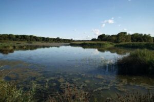
Name of element: Pialassa dei Piomboni, Pineta di Punta Marina
Date of the protection act:: 20/04/2009
Motivation of the protection: The site is located immediately south of the port-canal of Ravenna, the Candiano, in the coastal and sub-coastal area between the beaches of Marina di Ravenna and Punta Marina. La Pialassa partly used as a port area for the industrial port of Ravenna, coastal pine forest with Pinus pinaster between the pialassa and the sea and stretch of coast with relict strips of active dunes. The integration and synergy between the pine forest and Piallassa generates an ecosystem of great fauna, vegetation and landscape interest: numerous and important bird species take refuge in the Piallassa [and] there is the typical vegetation of marshy areas, such as marsh reeds and tamarisks , which together with other species constitute an important biotope, together with olive trees, locust trees, poplars, pines, yuccas, etc.. Eleven habitats of Community interest (four halophytic, three dune xerophilous herbaceous and three pine forest, holm oak forest and lowland oak forest) , of which three are priority areas, cover around three-quarters of the site's surface area.
Level of identification of the area as heritage by the community: This site is recognized as being of considerable interest both for its overall panoramic value, enjoyable from many points of view, and for having a characteristic aspect of landscape and aesthetic value such as a spontaneous concordance and fusion between the expression of nature and the work human, achieved above all in hydraulic, reforestation and reclamation works.
Historical value: preserved
Historical value motivation:
Cultural value: preserved
Cultural value motivation: Since the 18th century, the function of the Piallasse was to accommodate the flow of the incoming tide, limiting the level excursions on the canal, in order to keep the bottom of the Candiano canal free from deposits. On the north-eastern edge of the Piallassa there are industrial complexes built in the second half of the 17th century, which historically housed the services relating to the port.
Natural value: preserved
Natural value motivation: The natural value of the Pialassa is preserved both for the presence of numerous and important bird species and for the typical vegetation of the marshy areas, all this despite the significant anthropic presence, in fact the Pialassa is partly used as a port area. Even that of the Pineta is preserved as the high density of maritime pines limits both the biodiversity of the undergrowth and the presence of fauna.
Morphological value: preserved
Morphological value motivation:
Aesthetic value: preserved
Aesthetic value motivation: Used as a port area for the port of Ravenna, the Pialassa is a combination of natural environments and anthropic presence as the illegal shacks and the imposing industrial complexes create a scenic background from all points of view. The pine forest in turn, squeezed between the bathing establishments and the housing complex, has maintained its original aesthetic value.
Institution/Body in charge of the management of the site: Regione Emilia-Romagna - Direzione Generale Ambiente, Difesa del Suolo e della Costa - Servizio Parchi e Risorse forestali.
Main Cultural/Touristic points of interest within the site:
Is it possible to visit the site?: yes
Accessibility with reference to existing infrastructures in the Surrounding area for private mobility (car, bicycles, etc.):: Presence of a paved road that lead to the Infrastructure/Building/Archeological Site and of a parking in the surrounding area
Presence of a bicycle lane: no
Accessibility with reference to existing infrastructures for public means of transport - MoT (collective transport: bus, train, etc.): Easy to attain with public MoT (>500 and <1km)
Time of the survey:
Code: IT4070009
Name of element: Ortazzo, Ortazzino, Foce del Torrente Bevano
Date of the protection act:: 17/10/1988
Motivation of the protection: Description: It is one of the highest natural coastal sites. In it the natural succession from the sea to the hinterland is kept intact, without seaside settlements and anthropic tampering. It is one of the sites with the greatest environmental diversity in the coastal area of the region and has been subject to protection since 1988 due to the nature of its habitats, fauna and flora present:
- It has 18 habitats of community interest including estuaries, lagoons, annual vegetation of marine deposit lines, Spartina meadows, flooded Mediterranean pastures, salt steppes, mobile embryonic dunes and fixed dunes, Malcolmietalia dune meadows, coastal juniper perch, dune forests of Pinus pinea and Pinus pinaster, Mediterranean grasslands with tall herbaceous plants and rushes;
- 650 plant species surveyed and 47 targets of conservation interest;
- Numerous animal species of community interest;
Level of identification of the area as heritage by the community: The landscape and naturalistic values that have made this place a Site of Community Interest derive largely from the scarce anthropization in general of this stretch of coast, assisted by the citizen interest and in particular by the failed building speculation, which they opposed in half of the 70s of the last century citizens and protectionist associations.
Historical value: preserved
Historical value motivation:
Cultural value: preserved
Cultural value motivation: The natural evolution of the Bevano estuary has allowed the formation of oxbow lakes and river deaths that mark the position of the mouth in the past. The more recent oxbow was formed between 1945 and 1960 while the older one, included in the wetland known as Ortazzino, between 1900 and 1920. The area known as Ortazzo housed a freshwater marsh, which in the 90s was restored to maintain its original value.
Natural value: preserved
Natural value motivation: The great naturalistic value of this site lies in the presence of the natural succession of habitats: sea, inland marshes, active dunes and consolidated dunes on which the maritime pine forest has been planted, a mouth in free and natural evolution, lowlands behind the dunes and a salt marsh. This great environmental diversity leads to a remarkable faunal diversity. The changing nature of the Bevano estuary, the continuous erosion process of the sea and human interventions have not affected the natural value of the area, in which one of the greatest environmental diversity remains in the coastal area of the Region.
Morphological value: preserved
Morphological value motivation:
Aesthetic value: preserved
Aesthetic value motivation: The aesthetic value of this area, despite the natural evolution of the Bevano estuary, has been preserved over the years also thanks to the application of agri-environmental measures for wild fauna and flora.
Institution/Body in charge of the management of the site: Ente di gestione per i Parchi e la Biodiversità - Delta del Po
Main Cultural/Touristic points of interest within the site:
Is it possible to visit the site?: yes
Accessibility with reference to existing infrastructures in the Surrounding area for private mobility (car, bicycles, etc.):: Presence of a dirt road that lead to the Infrastructure/Building/Archeological Site, absence of a paved road and of a parking
Presence of a bicycle lane: no
Accessibility with reference to existing infrastructures for public means of transport - MoT (collective transport: bus, train, etc.): Difficult to attain public MoT (>1 and <3 km)
Time of the survey:
Code: IT_RA_24
Location / Address: Via Marabina, 7 Zona Ponte Nuovo-Classe, 48124 Ravenna, Italia.
Date of mapping: 09/07/2020
Property tipology: Public
State of occupancy: Occupied
State of preservation: Well preserved (no need of intervention) - (Score = 3)
Level of practicability: Total - (Score = 1)
Surrounding area: Yes - (Score = 1)
The ancient warehouses of the Porto di Classe are located inside the Archaeological Park of the Ancient Port. There are several structures created to accommodate tourists and there is a large garden where you can see the archaeological evidence. In the site it's possible organizing public events in total safety, there are roads, toilets, a parking and the bike path (see ANNEX 1).
Construction era: Medieval Era (VIII - XIV a.C.)
Buried archaeological remains: Certain presence of buried Archaeological remains – (Score = 3);
The site of the Classe port, and in particular the warehouses, evoke the possibility of the ancient landings to store goods and materials. These warehouses had a long life and when the port was covered up they were transformed into private houses (see ANNEX 2).
The site is located in a very popular tourist area and a short distance there is the Basilica di Sant 'Apollinare in Classe and the Classis Museum dedicated to the archaeological finds of the port.
Distance: D < 1 km
Organisation of internal spaces (related to "final intended use"): In the archaeological site there is a large structure created to accommodate tourists, has a large capacity and is equipped with all the necessary facilities to organize events. There are two other structures that can be used as storage or for special preparations (see ANNEX 3).
Structure and Material Characteristics: Bearing Masonry
State of the structure: The archaeological evidence is well preserved and continuously maintained. The public spaces are newly built, so they are in very good condition (see ANNEX 4).
Electrical System: Presence of a public network in the Surrounding Area, presence of connections to the public network, presence of systems in the Infrastructure/Building/Archeologic Site – (Score = 3)
Sanitary Installation: Presence of a public network in the Surrounding Area, presence of connections to the public network, presence of systems in the Infrastructure/Building/Archeologic Site – (Score = 3)
Gasworks: Presence of a public network in the Surrounding Area, presence of connections to the public network, presence of systems in the Infrastructure/Building/Archeologic Site – (Score = 3)
Existing infrastructure for private mobility: Presence of a paved road that lead to the Infrastructure/Building/Archeological Site and of a parking in the surrounding area – (Score = 3)
Presence of a bicycle lane: yes
Existing infrastructure for public means of transport: close to public MoT (<500 m) – (Score = 3)
The infrastructure/building/Archeological Site is considered as “Bounded Heritage”: yes
Which is the level of complexity of the administrative procedures to be adopted to manage it in terms of renovation/retrofit or Temporary Uses activation?: Facilitated – (Score = 2)
Code: IT_RA_23
Location / Address: Viale Vincenzo Randi 25, 48121 Ravenna, Italia.
Date of mapping: 07/06/2020
Property tipology: Public
State of occupancy: Occupied
State of preservation: Well preserved (no need of intervention) - (Score = 3)
Level of practicability: Partial - (Score = 0.5)
Surrounding area: Yes - (Score = 1)
The site represents the ancient Port of Augustus now buried and invisible. The area is occupied by the firehouse, but in the surrounding area it is possible to organize public events in total safety, but without hindering the transit of vehicles. This area is close to a very busy road, so it's necessary to use appropriate areas.
Construction era: Late Antique Era (IV - VII a.C.)
Buried archaeological remains: Certain presence of buried Archaeological remains – (Score = 3);
In this place was built the ancient port wanted by Augustus for the city of Ravenna, currently the structures are buried, but the site allows to evoke one of the numerous port realities of the city of Ravenna. It's impossible to determine with certainty how long this port was used, but from the imperial age it probably came up to the late antiquity (see ANNEX 1).
The main tourist place is Piazza Arcivescovado, where there are the Archiepiscopal Museum and the Neonian Baptistery. This place is 1 km far and the Square has been mapped as a point of interest for the Tempus project.
Distance: 1 km < D < 2 km
Organisation of internal spaces (related to "final intended use"): The area is occupied by the firehouse, but a large garden overlooks Viale Randi. There is no possibility of using indoor spaces and there's only external envelope: it is a large area with trees and lawn.
Structure and Material Characteristics: Other
State of the structure: The site is buried and preserved, no archaeological excavation has ever been made.
Electrical System: Presence of a public network in the Surrounding Area, total lack of systems in the Infrastructure/Building/Archeological Site, total lack of connections to the public network – (Score = 1)
Sanitary Installation: Presence of a public network in the Surrounding Area, total lack of systems in the Infrastructure/Building/Archeological Site, total lack of connections to the public network – (Score = 1)
Gasworks: Presence of a public network in the Surrounding Area, total lack of systems in the Infrastructure/Building/Archeological Site, total lack of connections to the public network – (Score = 1)
Existing infrastructure for private mobility: Presence of a paved road that lead to the Infrastructure/Building/Archeological Site and of a parking in the surrounding area – (Score = 3)
Presence of a bicycle lane: yes
Existing infrastructure for public means of transport: close to public MoT (<500 m) – (Score = 3)
The infrastructure/building/Archeological Site is considered as “Bounded Heritage”: no
Which is the level of complexity of the administrative procedures to be adopted to manage it in terms of renovation/retrofit or Temporary Uses activation?: Complicated – (Score = 0)
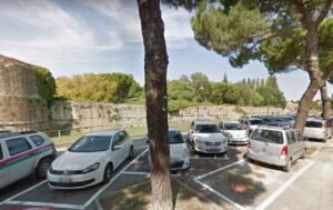
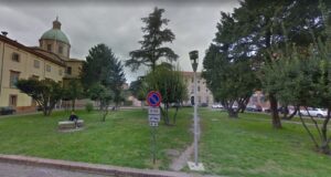
Code: IT_RA_22
Location / Address: Via Gastone de Foix, 48121 Ravenna, Italia.
Date of mapping: 01/07/2020
Property tipology: Public
State of occupancy: Occupied
State of preservation: Well preserved (no need of intervention) - (Score = 3)
Level of practicability: Total - (Score = 1)
Surrounding area: Yes - (Score = 1)
This site, currently used as a car park, represents the ancient port of Metello. The ruins are buried and are not visible. There are no buildings, but the large parking area is usable in total safety, there are also tall trees that shade the space below, while behind via Gastone de Foix there is the park of the Rocca Brancaleone that offers a sugegstive view (see ANNEX 1).
Construction era: Modern Era (XV – XVIII a.C.)
Buried archaeological remains: Certain presence of buried Archaeological remains – (Score = 3);
The site evokes the ancient Port of Metellus, where probably in 80 b.C. the soldiers of Metellus (allied with Silla) fired. It is one of the many ports of the city of Ravenna. This port was built before the great Augustan port and remained in use until at least the V century AD, but some maps of the city show that the waterways and the mouth of the ancient port had to be visible even in the XVI century. Some archaeological excavations have identified in this place the containment walls of the embankments of the port and the presence of palisades. It was a very large port that probably occupied the area of the railway station. The basilica of San Giovanni Evangelista shows the extension of the port, because Galla Placidia wanted to build this church on the docks as a votive offering to escape a shipwreck.
The Rocca Brancaleone is located behind the site. It is an extraordinary ancient monument and a meeting point for the people of Ravenna, especially during the summer beacuse of the large park and for the events that are organized here. About 300 meters far is the Basilica of San Giovanni Evangelista, connected to the ancient port of Metello and much appreciated tourist place (see ANNEX 2).
Distance: D < 1 km
Organisation of internal spaces (related to "final intended use"): The site is a parking lot, so there are no buildings, but only an external development. The area is large and usable in total safety.
Structure and Material Characteristics: Wood structure
State of the structure: The ancient structures were made of wood and lime. The structures are in a good state of conservation, but the evidence is buried (see ANNEX 4).
Electrical System: Presence of a public network in the Surrounding Area, presence of connections to the public network, total lack systems in the Infrastructure/Building/Archeological Site – (Score = 2)
Sanitary Installation: Presence of a public network in the Surrounding Area, presence of connections to the public network, total lack systems in the Infrastructure/Building/Archeological Site – (Score = 2)
Gasworks: Presence of a public network in the Surrounding Area, presence of connections to the public network, total lack systems in the Infrastructure/Building/Archeological Site – (Score = 2)
Existing infrastructure for private mobility: Presence of a paved road that lead to the Infrastructure/Building/Archeological Site and of a parking in the surrounding area – (Score = 3)
Presence of a bicycle lane: yes
Existing infrastructure for public means of transport: close to public MoT (<500 m) – (Score = 3)
The infrastructure/building/Archeological Site is considered as “Bounded Heritage”: no
Which is the level of complexity of the administrative procedures to be adopted to manage it in terms of renovation/retrofit or Temporary Uses activation?: Facilitated – (Score = 2)
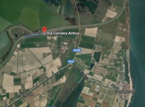
Code: IT_RA_21
Location / Address: Via Corriera Antica, 48123 Ravenna, Italia.
Date of mapping: 12/06/2020
Property tipology: Public
State of occupancy: Partly Occupied
State of preservation: Well preserved (no need of intervention) - (Score = 3)
Level of practicability: Total - (Score = 1)
Surrounding area: Yes - (Score = 1)
The site represents a stretch of the ancient Fossa Augusta of which no visible traces remain, but from some archival investigations and archaeological excavations it's possible to trace an hypothetical path. Therefore, it isn't a material heritage and there are no buildings. The place evokes this ancient reality and is located in an agricultural area where it's possibile to organize events in a large area in total safety (see ANNEX 1).
Construction era: Modern Era (XV – XVIII a.C.)
Buried archaeological remains: Certain presence of buried Archaeological remains – (Score = 3);
Regarding the topic of the portuality the Fossa Augusta played a fundamental role in maintaining drained the city of Ravenna and therefore allowed the terrestrial connections with the ports, it was also a channel navigable by small boats. This Roman infrastructure allowed the drainage of water far from the city and at the same time it was a connection with distant areas, as evidenced by the survival of some streets that bordered it. During the centuries the Fossa Augusta has always been maintained, up to the important land reclamations of the XVIII century.
It's an isolated site and far from tourist attractions.
Distance: D < 1 km
Organisation of internal spaces (related to "final intended use"): The site is destined to cultivated fields and it's in the countryside.
Structure and Material Characteristics: Other
State of the structure: There are no structures, the cultural heritage is immaterial.
Electrical System: Total lack of systems in the Infrastructure/Building/Archeological Site, total lack of connections to the public network and absence of a public network in the surrounding area – (Score = 0)
Sanitary Installation: Total lack of systems in the Infrastructure/Building/Archeological Site, total lack of connections to the public network and absence of a public network in the surrounding area – (Score = 0)
Gasworks: Total lack of systems in the Infrastructure/Building/Archeological Site, total lack of connections to the public network and absence of a public network in the surrounding area – (Score = 0)
Existing infrastructure for private mobility: Presence of a paved road that lead to the Infrastructure/Building/Archeological Site, absence of a parking – (Score = 2)
Presence of a bicycle lane: no
Existing infrastructure for public means of transport: Unattainable with public MoT (>3km) – (Score = 0)
The infrastructure/building/Archeological Site is considered as “Bounded Heritage”: no
Which is the level of complexity of the administrative procedures to be adopted to manage it in terms of renovation/retrofit or Temporary Uses activation?: Complicated – (Score = 0)
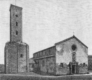
Code: IT_RA_20
Location / Address: Via Stradone 50, 48121 Porto Fuori (RA), Italia.
Date of mapping: 07/06/2020
Property tipology: Private
State of occupancy: Occupied
State of preservation: Well preserved (no need of intervention) - (Score = 3)
Level of practicability: Partial - (Score = 0.5)
Surrounding area: Yes - (Score = 1)
The site is characterized by the presence of a church and a bell tower that preserves some traces of the original plant dating back to 1100 a.D. The bell tower is in good condition and has been rebuilt and restored on several occasions. The surrounding area is intended as a garden, is safe and is served by a paved road. Once the permits have been obtained, it may also be possible to use the structure of the bell tower (see ANNEX 1).
Construction era: Contemporary Era (XIX a.C. – Today)
Buried archaeological remains: High probability (based on the available Archaeological information) – (Score = 2);
This site represents the ancient mouth of the Bidente river in the south of Ravenna, where was built a port. In fact, the difficult management of the marshy territories and the hydrographic network in which the port of Classe was located, meant that between the VIII and IX Century A.D. the main port center of the city was in Porto Fuori: a name that still evokes the function for which the place was intended. In this place around 1100 a.D. some monks built a church to house an icon arrived in Ravenna thanks to the connections with Constantinople.
The site is isolated and there are no touristic points of interest at a distance of less than 3 km.
Distance: D < 1 km
Organisation of internal spaces (related to "final intended use"): The structure is used as a bell tower. From the access the stairs lead to the openings to the top floor of the tower. There have been no changes in usage over time, but many remakes that have always maintained the appearance of the structure similar to the original (ANNEX 3). The interior spaces are very small, but outside there's a large garden that it's possible to use in total safety.
Structure and Material Characteristics: Bearing Masonry
State of the structure: The structure is well preserved and absolutely safe.
Electrical System: Presence of a public network in the Surrounding Area, presence of connections to the public network, presence of systems in the Infrastructure/Building/Archeologic Site – (Score = 3)
Sanitary Installation: Presence of a public network in the Surrounding Area, presence of connections to the public network, total lack systems in the Infrastructure/Building/Archeological Site – (Score = 2)
Gasworks: Presence of a public network in the Surrounding Area, presence of connections to the public network, total lack systems in the Infrastructure/Building/Archeological Site – (Score = 2)
Existing infrastructure for private mobility: Presence of a paved road that lead to the Infrastructure/Building/Archeological Site and of a parking in the surrounding area – (Score = 3)
Presence of a bicycle lane: no
Existing infrastructure for public means of transport: close to public MoT (<500 m) – (Score = 3)
The infrastructure/building/Archeological Site is considered as “Bounded Heritage”: no
Which is the level of complexity of the administrative procedures to be adopted to manage it in terms of renovation/retrofit or Temporary Uses activation?: Facilitated – (Score = 2)
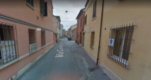
Code: IT_RA_19
Location / Address: Via Morigia, 48121 Ravenna (RA), Italia.
Date of mapping: 06/06/2020
Property tipology: Public
State of occupancy: Occupied
State of preservation: Ruin - (Score = 0)
Level of practicability: Partial - (Score = 0.5)
Surrounding area: Yes - (Score = 1)
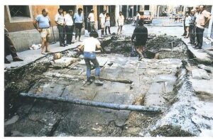
The area of interest is practicable in total safety. The site has no old buildings. In fact, this is the area where archaeological excavations have been carried out, bringing to light numerous ceramic finds and stratigraphies from the pre-Roman age. Currently the archaeological investigations are no longer visible and the area is occupied by a paved street and private homes (see ANNEX 1).
Construction era: Modern Era (XV – XVIII a.C.)
Buried archaeological remains: Certain presence of buried Archaeological remains – (Score = 3);
The role of the site in the port framework is very significant because many materials, found during excavations (which did not bring to light structures, but only mobile artifacts), were imported. Many ceramics, for example of Greek origin, were transported by ship to one of the ports of Ravenna and then traded and distributed in the city. The site evokes a commercial flow of ceramic vessels that through the port and the sea reached the city.
The site is in the city center and is located less than 200 m from the complex of the Basilica of San Vitale, one of the most important tourist attractions in Ravenna. Similarly, the CH element is located a short distance from the tourist information offices (see ANNEX 2).
Distance: D < 1 km
Organisation of internal spaces (related to "final intended use"): The site evokes the presence of objects imported from distant places, so there are no buildings or structures. Therefore it's impossible to describe the internal organization of the spaces. The area is currently an inhabited street of the city.
Structure and Material Characteristics: Other
State of the structure: The archaeological remains are simple stratigraphies of soil investigated with the excavation of vertical wells: there are no structures.
Electrical System: Presence of a public network in the Surrounding Area, presence of connections to the public network, total lack systems in the Infrastructure/Building/Archeological Site – (Score = 2)
Sanitary Installation: Presence of a public network in the Surrounding Area, presence of connections to the public network, total lack systems in the Infrastructure/Building/Archeological Site – (Score = 2)
Gasworks: Presence of a public network in the Surrounding Area, presence of connections to the public network, total lack systems in the Infrastructure/Building/Archeological Site – (Score = 2)
Existing infrastructure for private mobility: Presence of a paved road that lead to the Infrastructure/Building/Archeological Site and of a parking in the surrounding area – (Score = 3)
Presence of a bicycle lane: yes
Existing infrastructure for public means of transport: close to public MoT (<500 m) – (Score = 3)
The infrastructure/building/Archeological Site is considered as “Bounded Heritage”: no
Which is the level of complexity of the administrative procedures to be adopted to manage it in terms of renovation/retrofit or Temporary Uses activation?: Facilitated – (Score = 2)
Code: IT_RA_18
Location / Address: Via Salara 6, 48121 Ravenna (RA), Italia.
Date of mapping: 20/05/2020
Property tipology: Public
State of occupancy: Abandoned
State of preservation: Well preserved (no need of intervention) - (Score = 3)
Level of practicability: None - (Score = 0)
Surrounding area: Yes - (Score = 1)
Construction era: Medieval Era (VIII - XIV a.C.)
Buried archaeological remains: Certain presence of buried Archaeological remains – (Score = 3);
Organisation of internal spaces (related to "final intended use"):
Structure and Material Characteristics: Bearing Masonry
State of the structure:
Electrical System: Presence of a public network in the Surrounding Area, presence of connections to the public network, total lack systems in the Infrastructure/Building/Archeological Site – (Score = 2)
Sanitary Installation: Presence of a public network in the Surrounding Area, presence of connections to the public network, total lack systems in the Infrastructure/Building/Archeological Site – (Score = 2)
Gasworks: Presence of a public network in the Surrounding Area, presence of connections to the public network, total lack systems in the Infrastructure/Building/Archeological Site – (Score = 2)
Existing infrastructure for private mobility: Presence of a paved road that lead to the Infrastructure/Building/Archeological Site and of a parking in the surrounding area – (Score = 3)
Presence of a bicycle lane: yes
Existing infrastructure for public means of transport: close to public MoT (<500 m) – (Score = 3)
The infrastructure/building/Archeological Site is considered as “Bounded Heritage”: yes
Which is the level of complexity of the administrative procedures to be adopted to manage it in terms of renovation/retrofit or Temporary Uses activation?: Facilitated – (Score = 2)
Code: IT_RA_17
Location / Address: Via dell’Idrovora 51, Area Industriale - RA, Ravenna, Italia.
Date of mapping: 08/07/2020
Property tipology: Public
State of occupancy: Occupied
State of preservation: Well preserved (no need of intervention) - (Score = 3)
Level of practicability: Total - (Score = 1)
Surrounding area: Yes - (Score = 1)
The dewatering pump is managed by the Consorzio di Bonifica, a public body which controls water regulation. The plant is currently in use. All around there are green spaces and areas that could be the object of development (for example an abandoned inn) also in relation to the location, subject to verification of the availability of the area.
Construction era: Contemporary Era (XIX a.C. – Today)
Buried archaeological remains: Low probability (based on the available Archaeological information) – (Score = 1);
The S.Vitale dewatering pump was built by the Consorzio di Bonifica in the early 1900s, in 1932 during an important reclamation operation in the Ravenna area. Over the course of about 30 years, the Consortium built various plants, including that of the Fagiolo, Fosso gravel, Madonna del Pino in Cervia, the Rasponi plant in Punta Marina. The plants have dried important parts of the Ravenna area by means of mechanical reclamation, faster than by reclamation by filling.
The dewatering pump is near the Pialassa Piomboni and can be reached from Via Trieste. The connection with the white road of the "lungo Pialassa" is interesting, which leads through a suggestive panorama dotted with fishing huts up to Marina di Ravenna.
Distance: 1 km < D < 2 km
Organisation of internal spaces (related to "final intended use"): The building is not accessible because it is fenced and guarded. It consists of a small masonry volume on two levels. Presumably, given the common typology of similar systems, built at the beginning of the twentieth century, the ground floor could consist of a single room to house the lifting system.
Structure and Material Characteristics: Bearing Masonry
State of the structure: The supporting structure is in masonry. The roof covering is in brick. The building is in a fairly good state of conservation.
Electrical System: Presence of a public network in the Surrounding Area, presence of connections to the public network, presence of systems in the Infrastructure/Building/Archeologic Site – (Score = 3)
Sanitary Installation: Presence of a public network in the Surrounding Area, presence of connections to the public network, presence of systems in the Infrastructure/Building/Archeologic Site – (Score = 3)
Gasworks: Presence of a public network in the Surrounding Area, presence of connections to the public network, presence of systems in the Infrastructure/Building/Archeologic Site – (Score = 3)
Existing infrastructure for private mobility: Presence of a paved road that lead to the Infrastructure/Building/Archeological Site and of a parking in the surrounding area – (Score = 3)
Presence of a bicycle lane: yes
Existing infrastructure for public means of transport: close to public MoT (<500 m) – (Score = 3)
The infrastructure/building/Archeological Site is considered as “Bounded Heritage”: no
Which is the level of complexity of the administrative procedures to be adopted to manage it in terms of renovation/retrofit or Temporary Uses activation?: Complicated – (Score = 0)
The intervention on the structure aimed at a possible temporary reuse must first of all foresee an agreement with the managing body with a view to enhancing the heritage relating to the testimony of the mechanical reclamation carried out thanks to the water pumps of the early twentieth century.
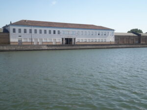
Code: IT_RA_16
Location / Address: Via Manfredi Eustachio 2, RA, Ravenna, Italia.
Date of mapping: 07/08/2020
Property tipology: Private
State of occupancy: Abandoned
State of preservation: Mostly rickety/unsafe - (Score = 0)
Level of practicability: None - (Score = 0)
Surrounding area: Yes - (Score = 1)
The sector is currently in a state of degradation, particularly on the quay front. The area is very large and includes several buildings including industrial archeology, in addition to the "palazzo" former caretaker's house between via Manfredi Eustachio and via Montecatini. Among the buildings there are the pertinent open spaces which, barring cleaning, static and environmental safety, could be used for triggering events, also in relation to the forecasts of the planning tool in force.
Construction era: Contemporary Era (XIX a.C. – Today)
Buried archaeological remains: Absence of buried Archaeological remains or absence of Archaeological information about the site – (Score = 0);
The Silos Granari of the Candiano company was founded in 1925, and following this constitution three buildings were erected in place of the portland cement factory. A two-storey building, on the corner between via Montecatini and via Manfredi, housed the offices and lodgings of the caretaker.
The area is located on the left bank of the Candiano Canal and is close to the main parks and places of historical and cultural interest of the city, including: Rocca Brancaleone, Park and Mausoleum of Theodoric, Piazza del Popolo, Basilica of Sant' apollinare Nuovo, etc.
Distance: 1 km < D < 2 km
Organisation of internal spaces (related to "final intended use"): The building was born on a cement factory in 1925 and over time the original layout was remodeled in particular to accommodate the machinery dedicated to the storage of cereals and grains, while maintaining the scenographic aspect of the large masonry vaults unchanged.
Structure and Material Characteristics: Bearing Masonry
State of the structure: The structure is in masonry and is in a very bad state of conservation. Many parts have collapsed and in some cases even crumbled.
Electrical System: Presence of a public network in the Surrounding Area, total lack of systems in the Infrastructure/Building/Archeological Site, total lack of connections to the public network – (Score = 1)
Sanitary Installation: Presence of a public network in the Surrounding Area, total lack of systems in the Infrastructure/Building/Archeological Site, total lack of connections to the public network – (Score = 1)
Gasworks: Presence of a public network in the Surrounding Area, total lack of systems in the Infrastructure/Building/Archeological Site, total lack of connections to the public network – (Score = 1)
Existing infrastructure for private mobility: Presence of a paved road that lead to the Infrastructure/Building/Archeological Site and of a parking in the surrounding area – (Score = 3)
Presence of a bicycle lane: yes
Existing infrastructure for public means of transport: close to public MoT (<500 m) – (Score = 3)
The infrastructure/building/Archeological Site is considered as “Bounded Heritage”: no
Which is the level of complexity of the administrative procedures to be adopted to manage it in terms of renovation/retrofit or Temporary Uses activation?: Ordinary – (Score = 1)
The building is currently abandoned. The path to allow temporary uses follows the current legislation with an ordinary path.
Code: IT_RA_15
Location / Address: piazzale Aldo Moro, RA, Ravenna, Italia.
Date of mapping: 08/07/2020
Property tipology: Public
State of occupancy: Occupied
State of preservation: Need of minor interventions on non-structural elements - (Score = 2)
Level of practicability: Total - (Score = 1)
Surrounding area: Yes - (Score = 1)
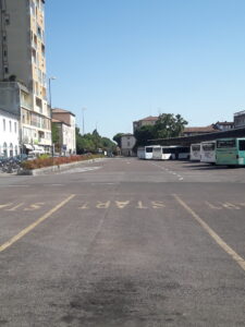
After the Second World War, the Darsena of "sailing boats" or Darsena Bidente, built at the end of the Corsini Canal in the mid-1700s, was buried following the reconstruction works of the canal port and the quays to make way for a yard for handling of means of transport. In the 1980s the square will be named after Aldo Moro. Currently the square is used as a parking lot as well as a bus station.
Construction era: Modern Era (XV – XVIII a.C.)
Buried archaeological remains: High probability (based on the available Archaeological information) – (Score = 2);
The Darsena Bidente, built at the end of the Corsini Canal, occupied the old course of the Bidente drainage and ran parallel to the railway and at the end it bordered the church of San Simone and Guida. It was in communication with the Bidente drain through two arches near the bridge in via "al Candiano" which led to the double-level docks which allowed both wooden sailing ships and steamers to dock depending on the tides at a later date. At the end of the 19th century almost all port activity took place to the right and left of this dock which houses the port warehouses designed in 1780 by Camillo Morigia. In this area there were also taverns and inns and it was the beating heart of the commercial and productive activity of the port.
Piazzale Aldo Moro, in addition to hosting the courier terminal, is near the railway station to which it is connected by a pedestrian and cycle underpass, through which you can reach the historic center and the main monuments of the city with short distances.
Distance: D < 1 km
Organisation of internal spaces (related to "final intended use"): The Darsena Bidente was buried after the Second World War, around 1950, and has become a goods handling yard and in recent times an area used for parking and a courier terminal.
Structure and Material Characteristics: Other
State of the structure: Piazzale Aldo Moro needs functional reorganization as well as enhancement in terms of connection between the "city dock" and the historic city, as a strategic area for use and the cycle-pedestrian connection as well as vehicular.
Electrical System: Presence of a public network in the Surrounding Area, presence of connections to the public network, presence of systems in the Infrastructure/Building/Archeologic Site – (Score = 3)
Sanitary Installation: Presence of a public network in the Surrounding Area, presence of connections to the public network, presence of systems in the Infrastructure/Building/Archeologic Site – (Score = 3)
Gasworks: Presence of a public network in the Surrounding Area, presence of connections to the public network, presence of systems in the Infrastructure/Building/Archeologic Site – (Score = 3)
Existing infrastructure for private mobility: Presence of a paved road that lead to the Infrastructure/Building/Archeological Site and of a parking in the surrounding area – (Score = 3)
Presence of a bicycle lane: yes
Existing infrastructure for public means of transport: close to public MoT (<500 m) – (Score = 3)
The infrastructure/building/Archeological Site is considered as “Bounded Heritage”: no
Which is the level of complexity of the administrative procedures to be adopted to manage it in terms of renovation/retrofit or Temporary Uses activation?: Facilitated – (Score = 2)
Piazzale Aldo Moro already hosts local initiatives and events, even temporary ones. The request for temporary events or uses falls within the scope of initiatives on public land.
Code: IT_RA_14
Location / Address: Via D'Alaggio 75, Ravenna RA, Italia.
Date of mapping: 20/06/2020
Property tipology: Private
State of occupancy: Partly Occupied
State of preservation: Need of interventions on structural framework - (Score = 1)
Level of practicability: Total - (Score = 1)
Surrounding area: Yes - (Score = 1)
The former Pansac offices overlook via d'Alaggio, with two long masonry facades decorated with stone motifs dating back to the establishment as a Romagna canapificio born in 1905, still based on a project by the architect. Camillus Morigia. From the central body, which has been remodelled, one enters an internal courtyard which distributes the production activities of Raviplast still in operation. Compatibly with existing activities and in relation to the forecasts of the planning tool in force,
Construction era: Contemporary Era (XIX a.C. – Today)
Buried archaeological remains: Absence of buried Archaeological remains or absence of Archaeological information about the site – (Score = 0);
This building was built in 1905 as a Romagna canapificio and served with the production of jute bags almost all the sugar factories in northern Italy. The first changes take place after the first 15 years of activity, the plant has already been transformed for the first time into a jute factory, from Montecatini, the intended use it covers until 1970.
The area is located on the right bank of the Candiano Canal and is close to the main parks and places of historical and cultural interest in the city, including: Rocca Brancaleone, Park and Mausoleum of Theodoric, Piazza del Popolo, Basilica of Sant' apollinare Nuovo, etc.
Distance: 1 km < D < 2 km
Organisation of internal spaces (related to "final intended use"): The building is and continues to be a factory, i.e. a place intended for productive activity. The layout was partially remodeled in the 1950s for the central body, while the two masonry wings remain unchanged in their prestigious appearance.
Structure and Material Characteristics: Bearing Masonry
State of the structure: The structure is in masonry and is in a good state of conservation as regards the accessible portion of the compartment. The older wings in masonry do not show evident signs of instability or even of important transformations.
Electrical System: Presence of a public network in the Surrounding Area, presence of connections to the public network, presence of systems in the Infrastructure/Building/Archeologic Site – (Score = 3)
Sanitary Installation: Presence of a public network in the Surrounding Area, presence of connections to the public network, presence of systems in the Infrastructure/Building/Archeologic Site – (Score = 3)
Gasworks: Presence of a public network in the Surrounding Area, presence of connections to the public network, presence of systems in the Infrastructure/Building/Archeologic Site – (Score = 3)
Existing infrastructure for private mobility: Presence of a paved road that lead to the Infrastructure/Building/Archeological Site and of a parking in the surrounding area – (Score = 3)
Presence of a bicycle lane: yes
Existing infrastructure for public means of transport: close to public MoT (<500 m) – (Score = 3)
The infrastructure/building/Archeological Site is considered as “Bounded Heritage”: no
Which is the level of complexity of the administrative procedures to be adopted to manage it in terms of renovation/retrofit or Temporary Uses activation?: Ordinary – (Score = 1)
The building is currently used even if not in its entirety. The path to allow temporary uses follows current legislation, net of any relocation of workers who are currently operating in the area itself.
Code: IT_RA_13
Location / Address: Via Molo Dalmazia 51_ Marina di Ravenna- RA, Ravenna, Italia.
Date of mapping: 25/06/2020
Property tipology: Public
State of occupancy: Partly Occupied
State of preservation: Need of interventions on structural framework - (Score = 1)
Level of practicability: Partial - (Score = 0.5)
Surrounding area: Yes - (Score = 1)
The former fish market in Marina di Ravenna overlooks the Dalmazia wharf where the charming fishing boats that carry out daily fishing activities are moored. Currently the building has been partially recovered and reopened as an Experimental Center for the development of fishing support activities and managed by Cestha, an association of young biologists and researchers.
Construction era: Contemporary Era (XIX a.C. – Today)
Buried archaeological remains: Absence of buried Archaeological remains or absence of Archaeological information about the site – (Score = 0);
The former fish market was built in 1939 in place of an old iron and sheet metal building from the 1920s. It was immediately considered one of the most modern sales structures in Italy, above all due to the presence of an electromechanical auction system which allowed faster sales and with fewer disputes which took place in the large amphitheater-like hall to which buyers had access. Until the Second World War the Marina market boasted a national importance, with over 100 fishing boats accessing the pier every day. Gradually, with the replacement of sailing boats with motor trawlers and with the industrialization of a good stretch of the Candiano Canal, many fishing families moved to nearby markets (Cesenatico, Chioggia, Cervia, Rimini, etc.) and the associated market of Marina will drastically decrease, until the total decline in the 70s.
the former market is located near the bathing establishments and the main tourist attractions and nature trails, both on the Marina di Ravenna side and on the Porto Corsini side, from which it is also connected by ferry.
Distance: D < 1 km
Organisation of internal spaces (related to "final intended use"): the monument made of travertine depicts a sailor wearing an oilskin and looking towards the entrance to the city port of the "Darsena" and towards the industrial archeology area of the port. It is placed on a base covered in stone. It is currently made inaccessible because it is in a state of decay.
Structure and Material Characteristics: Bearing Masonry
State of the structure: The former market, now the headquarters of the Cestha association, has the original layout and with few transformations. The right wing is more degraded and in a state of neglect, as is part of the roof and shed towards the courtyard, which should be redeveloped.
Electrical System: Presence of a public network in the Surrounding Area, presence of connections to the public network, presence of systems in the Infrastructure/Building/Archeologic Site – (Score = 3)
Sanitary Installation: Presence of a public network in the Surrounding Area, presence of connections to the public network, presence of systems in the Infrastructure/Building/Archeologic Site – (Score = 3)
Gasworks: Presence of a public network in the Surrounding Area, presence of connections to the public network, presence of systems in the Infrastructure/Building/Archeologic Site – (Score = 3)
Existing infrastructure for private mobility: Presence of a paved road that lead to the Infrastructure/Building/Archeological Site and of a parking in the surrounding area – (Score = 3)
Presence of a bicycle lane: yes
Existing infrastructure for public means of transport: close to public MoT (<500 m) – (Score = 3)
The infrastructure/building/Archeological Site is considered as “Bounded Heritage”: no
Which is the level of complexity of the administrative procedures to be adopted to manage it in terms of renovation/retrofit or Temporary Uses activation?: Facilitated – (Score = 2)
The building is already home to an association of researchers and organizes training, dissemination and research activities. It also hosts events. With additional resources it would also be interesting to enhance the courtyard and the street views.
Code: IT_RA_12
Location / Address: Via Cimitero , Banchina canale Candiano - RA, Ravenna, Italia.
Date of mapping: 25/06/2020
Property tipology: Public
State of occupancy: Abandoned
State of preservation: Need of interventions on structural framework - (Score = 1)
Level of practicability: None - (Score = 0)
Surrounding area: Yes - (Score = 1)
The monument to the fallen of the sea, positioned on the left bank of the Candiano canal, near the entrance square to the monumental cemetery of Ravenna, is located close to a pine grove overlooking the canal, to which one descends via a staircase that accompanies the sailor's gaze. This is the only point of the quay that in fact slopes down towards the water. The area in front of the monument could be the stage of connecting routes with the entire dock if redeveloped.
Construction era: Contemporary Era (XIX a.C. – Today)
Buried archaeological remains: Absence of buried Archaeological remains or absence of Archaeological information about the site – (Score = 0);
The monument to the Sailor of Ravenna is the work of the sculptor Giannantonio Bucci of Ravenna. It was built in 1963 by the ANMI (National Association of Italian Sailors) and located near the monumental cemetery facing south-east, near the entrance to the city dock, located there to greet the merchant ships that they passed through it, as a sign of protection. The monument is made of travertine and bears an inscription which is the incipit of the prayer of the Sailor, written by Fogazzaro in 1901 "To you, o great eternal God, whom the winds and the waves obey". The monument is located near the quay that leads to the monumental cemetery and a stairway that brings the quay closer to the water, as well as being immersed in the "pinetina", a residual fragment of the pine grove reduced during the industrial expansion of the commercial port at the end of the 1800s.
Il monumento al Marinaio è in prossimità del cimitero monumentale di Ravenna, da cui dista 150m; è inoltre a circa 2,2 Km dal parco e mausoleo Teodorico e 2,7 dalla Rocca Brancaleone.
Distance: 2 km < D < 3 km
Organisation of internal spaces (related to "final intended use"): The monument made of travertine depicts a sailor wearing an oilskin and looking towards the entrance to the city port of the "Darsena" and towards the industrial archeology area of the port. It is placed on a base covered in stone. It is currently made inaccessible because it is in a state of decay.
Structure and Material Characteristics: Other
State of the structure: The statue is made of travertine and now both it and the base on which it rests are in a state of decay.
Electrical System: Presence of a public network in the Surrounding Area, total lack of systems in the Infrastructure/Building/Archeological Site, total lack of connections to the public network – (Score = 1)
Sanitary Installation: Presence of a public network in the Surrounding Area, total lack of systems in the Infrastructure/Building/Archeological Site, total lack of connections to the public network – (Score = 1)
Gasworks: Total lack of systems in the Infrastructure/Building/Archeological Site, total lack of connections to the public network and absence of a public network in the surrounding area – (Score = 0)
Existing infrastructure for private mobility: Presence of a paved road that lead to the Infrastructure/Building/Archeological Site and of a parking in the surrounding area – (Score = 3)
Presence of a bicycle lane: yes
Existing infrastructure for public means of transport: close to public MoT (<500 m) – (Score = 3)
The infrastructure/building/Archeological Site is considered as “Bounded Heritage”: no
Which is the level of complexity of the administrative procedures to be adopted to manage it in terms of renovation/retrofit or Temporary Uses activation?: Complicated – (Score = 0)
The monument requires restoration. The neighboring area and therefore the monument itself could be enhanced by inserting the place within demonstrations, events, walks aimed at spreading the port heritage. In these terms, temporary use could facilitate the installation of small structures to support them.
Code: IT_RA_11
Location / Address: Via del Muro Lungo, Ravenna, RA, Italia.
Date of mapping: 28/01/2020
Property tipology: Private
State of occupancy: Occupied
State of preservation: Well preserved (no need of intervention) - (Score = 3)
Level of practicability: Total - (Score = 1)
Surrounding area: Yes - (Score = 1)
The structures of the ancient docks are currently buried. The area is intended for cultivation, therefore there are large spaces available in total safety (see ANNEX 1).
Construction era: Medieval Era (VIII - XIV a.C.)
Buried archaeological remains: Certain presence of buried Archaeological remains – (Score = 3);
The site plays a significant role in the port framework because it represents one of the main port evidences: the docks. The docks overlooked a basin of water connected to the sea and allows to understand how goods and people moved. It is necessary to imagine the densely populated structures where busy people loaded the products on the boats and concluded the exchange talks.
About 700 meters far there is the archaeological area of the ancient port of Classe: a tourist place widely sponsored and known by both local population and tourists.
Distance: D < 1 km
Organisation of internal spaces (related to "final intended use"): It's impossible to describe internal spaces due to the morphology of the evidence: these are port docks therefore no spaces are to be considered closed, with the exception of the port warehouses which, however, are located in the archaeological area of the ancient port. The area has changed a lot during the ages and what in late ancient times was in contact with the waters is now buried beacuse of the subsidence phenomenon. The field is cultivated and the archaeological evidence is visible only as crop marks.
Structure and Material Characteristics: Bearing Masonry
State of the structure: The structures of the docks had to be composed of masonry parts and wooden elements, such as poles and walkways - in accordance with the archaeological excavations of the 60s. Currently the ruins are not visible because they are buried (see ANNEX 3).
Electrical System: Presence of a public network in the Surrounding Area, total lack of systems in the Infrastructure/Building/Archeological Site, total lack of connections to the public network – (Score = 1)
Sanitary Installation: Presence of a public network in the Surrounding Area, total lack of systems in the Infrastructure/Building/Archeological Site, total lack of connections to the public network – (Score = 1)
Gasworks: Presence of a public network in the Surrounding Area, presence of connections to the public network, total lack systems in the Infrastructure/Building/Archeological Site – (Score = 2)
Existing infrastructure for private mobility: Presence of a dirt road that lead to the Infrastructure/Building/Archeological Site, absence of a paved road and of a parking – (Score = 1)
Presence of a bicycle lane: yes
Existing infrastructure for public means of transport: Easy to attain with public MoT (>500 and <1km) – (Score = 2)
The infrastructure/building/Archeological Site is considered as “Bounded Heritage”: yes
Which is the level of complexity of the administrative procedures to be adopted to manage it in terms of renovation/retrofit or Temporary Uses activation?: Complicated – (Score = 0)
Organizing events in this location may require a higher level of complexity due to the private ownership of the field. In the surrounding area there are public electricity, gas and sanitary networks, but the site is totally devoid of facilities, therefore it would be necessary to install all the necessary equipment. The site is considered a bounded heritage, but there is no possibility of damage to the ancient buried structures. The place is easily reachable with both private and public vehicles and it's served by a nearby bicycle lane, however is necessary to reach the site on foot because of the parking and bus stop located at the site of the ancient port.

Code: IT_RA_10
Location / Address: Via Romea Vecchia, 115, Ravenna, RA, Italia.
Date of mapping: 25/02/2020
Property tipology: Private
State of occupancy: Occupied
State of preservation: Need of minor interventions on non-structural elements - (Score = 2)
Level of practicability: Total - (Score = 1)
Surrounding area: Yes - (Score = 1)
The archaeological site is completely buried, so the area of interest is absolutely practicable in total safety. There are no buildings, it is a private field intended for cultivation, therefore no structural interventions are needed (see ANNEX 1).
Construction era: Medieval Era (VIII - XIV a.C.)
Buried archaeological remains: Certain presence of buried Archaeological remains – (Score = 3);
The site evokes the ancient walls of Classe, a space near Ravenna intended for a specific function: a port city. Within these walls goods and people arrived, ships docked and sailors lived there. Over the centuries Classe was always a port and the walls from the fifth to the tenth century maintained their defensive function.
About 700 meters from the site, to the east, stands the ancient port of Classe. In the opposite direction, about 1.5 kilometers far, there is the Basilica of Sant'Apollinare in Classe and the new museum dedicated to the port city. At a very short distance there are also the archaeological excavations of the monastery of San Severo, currently not open to visitors. The places mentioned consist of large gathering spaces for the local community and tourists.
Distance: D < 1 km
Organisation of internal spaces (related to "final intended use"): The site has no buildings and the current use is for cultivation.
Structure and Material Characteristics: Bearing Masonry
State of the structure: The archaeological structures are in bearing masonry, but are currently buried and invisible. The area at the time of the inspection is a plowed field. ANNEX 3
Electrical System: Presence of a public network in the Surrounding Area, total lack of systems in the Infrastructure/Building/Archeological Site, total lack of connections to the public network – (Score = 1)
Sanitary Installation: Presence of a public network in the Surrounding Area, total lack of systems in the Infrastructure/Building/Archeological Site, total lack of connections to the public network – (Score = 1)
Gasworks: Presence of a public network in the Surrounding Area, total lack of systems in the Infrastructure/Building/Archeological Site, total lack of connections to the public network – (Score = 1)
Existing infrastructure for private mobility: Presence of a paved road that lead to the Infrastructure/Building/Archeological Site, absence of a parking – (Score = 2)
Presence of a bicycle lane: yes
Existing infrastructure for public means of transport: close to public MoT (<500 m) – (Score = 3)
The infrastructure/building/Archeological Site is considered as “Bounded Heritage”: yes
Which is the level of complexity of the administrative procedures to be adopted to manage it in terms of renovation/retrofit or Temporary Uses activation?: Complicated – (Score = 0)
This area is large and safe, but it is privately owned. Normally cultivated land is not easily disposed for other purposes. There are public electricity, gas and sewer networks, but the field is totally isolated from the local system. The site is a bounded heritage, but it will be impossible to cause any damage to the buried structures. The site is easily accessible by any vehicle, the closest parking is at the site of the ancient port of Classe, but the via Romea Vecchia, with few traffic, allows to park some cars on the edge. Public transportation serves the area very well. So the only difficulties that can be found are related to the permits to use the area and to the recruitment of facilities.
Code: IT_RA_09
Location / Address: Piazza Arcivescovado, Ravenna, RA, Italia.
Date of mapping: 20/02/2020
Property tipology: Public
State of occupancy: Occupied
State of preservation: Well preserved (no need of intervention) - (Score = 3)
Level of practicability: Total - (Score = 1)
Surrounding area: Yes - (Score = 1)
The archaeological building is buried. The surface area is occupied by a large public garden and the remains are partially preserved in the vault of the Banca Popolare di Ravenna. The area of Piazza dell'Arcivescovado is usable in total safety and is suitable for all kinds of events (see ANNEX 1).
Construction era: Medieval Era (VIII - XIV a.C.)
Buried archaeological remains: Certain presence of buried Archaeological remains – (Score = 3);
The site is part of the port theme because of the ancient presence of water. The main ports of the ancient Ravenna were connected by roads intertwined with the intricate system of canals inside the city. These canals and rivers allowed the population to move and reach various places, as happens nowadays in Venice. The waters were therefore a connection system as much as the ports, but at the same time they allowed to keep structures, like the bath, operating.
In the same site there is the Archiepiscopal Museum, where Massimiano's ebony Chair is kept, there are also the ancient Neonian baptistery and the city cathedral.
Distance: D < 1 km
Organisation of internal spaces (related to "final intended use"): The site evokes an ancient reality currently buried, therefore it's impossible to establish the organization of the internal spaces. However, the area of interest is a city garden (see ANNEX 3).
Structure and Material Characteristics: Bearing Masonry
State of the structure: The ancient structures are characterized by bearing masonry, but currently the area is intended for trees and gardens.
Electrical System: Presence of a public network in the Surrounding Area, presence of connections to the public network, presence of systems in the Infrastructure/Building/Archeologic Site – (Score = 3)
Sanitary Installation: Presence of a public network in the Surrounding Area, presence of connections to the public network, total lack systems in the Infrastructure/Building/Archeological Site – (Score = 2)
Gasworks: Presence of a public network in the Surrounding Area, presence of connections to the public network, total lack systems in the Infrastructure/Building/Archeological Site – (Score = 2)
Existing infrastructure for private mobility: Presence of a paved road that lead to the Infrastructure/Building/Archeological Site and of a parking in the surrounding area – (Score = 3)
Presence of a bicycle lane: no
Existing infrastructure for public means of transport: close to public MoT (<500 m) – (Score = 3)
The infrastructure/building/Archeological Site is considered as “Bounded Heritage”: yes
Which is the level of complexity of the administrative procedures to be adopted to manage it in terms of renovation/retrofit or Temporary Uses activation?: Facilitated – (Score = 2)
The space is managed by the municipality, therefore it will be easier to obtain permits for temporary activities. The presence of public toilets in the surrounding area, of the public electricity network, of several parking lots, the proximity to the city center and the possibility of attracting a good number of people are all elements that allow an easy organizational level for the events.
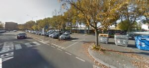
Code: IT_RA_08
Location / Address: Via Teodorico, 47122 Ravenna RA
Date of mapping: 19/02/2020
Property tipology: Public
State of occupancy: Partly Occupied
State of preservation: Well preserved (no need of intervention) - (Score = 3)
Level of practicability: None - (Score = 0)
Surrounding area: Yes - (Score = 1)
There is no archaeological building and the place qualifies an intangible heritage, therefore it is possible to organize events in a large area of interest. Currently the location is used as a parking lot so there are large spaces that can be enjoyed in total safety.
Construction era: Medieval Era (VIII - XIV a.C.)
Buried archaeological remains: Certain presence of buried Archaeological remains – (Score = 3);
About the port framework, the place shows the position of a stretch of the ancient coastline and than an area in which boats, goods and people moved in ancient times. The position is obtained from the ancient lighthouse at the Theoderic's mausoleum during the medieval age.
At 200 meters from this place there is the site of the mausoleum of Theoderic, built during the sixth century for the king of the Goths. In later periods, the building was used as a lighthouse to signal the coast to ships, then as church and monastery. In Roman times the area was a burial ground outside the city walls. (see ANNEX 1).
Distance: D < 1 km
Organisation of internal spaces (related to "final intended use"): The area is currently used as a parking lot, there are no ancient buildings. The ancient coast line is covered by modern and contemporary structures, including streets, parking lots, facilities and buildings. Therefore it's impossible to describe the internal space of the building or the construction material. Nonetheless, the area evokes the intangible heritage even if it has been altered during the ages.
Structure and Material Characteristics: Other
State of the structure: Intangible heritage.
Electrical System: Presence of a public network in the Surrounding Area, presence of connections to the public network, presence of systems in the Infrastructure/Building/Archeologic Site – (Score = 3)
Sanitary Installation: Presence of a public network in the Surrounding Area, presence of connections to the public network, total lack systems in the Infrastructure/Building/Archeological Site – (Score = 2)
Gasworks: Presence of a public network in the Surrounding Area, presence of connections to the public network, total lack systems in the Infrastructure/Building/Archeological Site – (Score = 2)
Existing infrastructure for private mobility: Presence of a paved road that lead to the Infrastructure/Building/Archeological Site and of a parking in the surrounding area – (Score = 3)
Presence of a bicycle lane: yes
Existing infrastructure for public means of transport: close to public MoT (<500 m) – (Score = 3)
The infrastructure/building/Archeological Site is considered as “Bounded Heritage”: no
Which is the level of complexity of the administrative procedures to be adopted to manage it in terms of renovation/retrofit or Temporary Uses activation?: Facilitated – (Score = 2)
The space is illuminated by the public network. There are no sanitary installations, but it will be the possibility to connect the non-permanent structures to the public system. There are many parking spaces and a large paved road. The place is well served by many bus lines. There is a bicycle lane that start from the city center and from train station; there are also some facilities for parking bikes. The space is wide enough to allow the installation of new structures. It's a public space, so it will be easier get permission for events. The area is served by a restaurant and a kiosk.
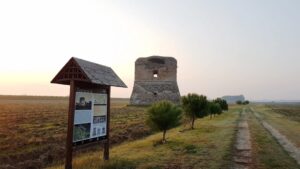
Code: IT_RA_07
Location / Address: Via Marabina, 153, 48124 Ravenna RA
Date of mapping: 17/02/2020
Property tipology: Public
State of occupancy: Abandoned
State of preservation: Need of minor interventions on non-structural elements - (Score = 2)
Level of practicability: Partial - (Score = 0.5)
Surrounding area: Yes - (Score = 1)
There is the possibility to organize public events in part of the archaeological site, but not inside the building for reasons of preservation of the monument. The surrounding area is in safe conditions and allows any kind of organization.
Construction era: Modern Era (XV – XVIII a.C.)
Buried archaeological remains: Certain presence of buried Archaeological remains – (Score = 3);
The Torraccia is what remains of the coastal watchtower which, at the time of construction, was located at the Candiano port entrance, in the south of Ravenna.This port was built in medieval times at the mouth of the Candiano stream, which connected the sea to the Candiana Valley (later called Standiana), the large marsh near the Classe pine forest. The construction of the tower of the Candiano port, known as Turaza, was commissioned by Cardinal Paolo Savelli in 1667. It was the seat of a garrison that controlled the coast preventing unwanted landings and signaling suspicious or enemy boats to the coastal defense system. It was also called Sanità tower, for the sanitary control that was carried out on the crews of the boats.
Near the site of Torraccia there is the important Byzantine curch (6th century) dedicated to Sant'Apollinare in Classe.
Distance: 2 km < D < 3 km
Organisation of internal spaces (related to "final intended use"): The internal spaces was not accessible during the survey, but probabily the plant scheme is simple: an empty quadrangular space. During the last century the tower was employed as a shed for agricultural tools.
Structure and Material Characteristics: Bearing Masonry
State of the structure: The structure is made of bricks tied with mortar. There are some corner elements in white stone inserted in the string course of the first floor. The building is divided into two overlapped blocks. The main facade is marked by two entrances, one on the ground floor and the other on the upper floor, without stairs (perhaps originally made of wood), the remaining walls have windows. Some furnishing elements, such as shelves and lamp holders, are made with iron.
Electrical System: Presence of a public network in the Surrounding Area, total lack of systems in the Infrastructure/Building/Archeological Site, total lack of connections to the public network – (Score = 1)
Sanitary Installation: Presence of a public network in the Surrounding Area, total lack of systems in the Infrastructure/Building/Archeological Site, total lack of connections to the public network – (Score = 1)
Gasworks: Total lack of systems in the Infrastructure/Building/Archeological Site, total lack of connections to the public network and absence of a public network in the surrounding area – (Score = 0)
Existing infrastructure for private mobility: Presence of a dirt road that lead to the Infrastructure/Building/Archeological Site, absence of a paved road and of a parking – (Score = 1)
Presence of a bicycle lane: no
Existing infrastructure for public means of transport: Easy to attain with public MoT (>500 and <1km) – (Score = 2)
The infrastructure/building/Archeological Site is considered as “Bounded Heritage”: yes
Which is the level of complexity of the administrative procedures to be adopted to manage it in terms of renovation/retrofit or Temporary Uses activation?: Ordinary – (Score = 1)
It will be necessary to connect the electricity in order to illuminate the space during the dark hours. There are no sanitary installations, so it will be useful bringing non-permanent structures. There are no parking spaces, but the dirt road is long enough to guarantee cars to park. The place is well served by bus line number 4. A bicycle lane is missing, but the main road allows the transit of bikes. The space around the evidence is large and allows the installation of new structures. It's a public structure, so it will be easier get permission for events.

Code: IT_RA_06
Location / Address: Costa Mare Adriatico - impianto Offshore
Date of mapping: 18/11/2019
Property tipology: Public
State of occupancy: Partly Occupied
State of preservation: Need of minor interventions on non-structural elements - (Score = 2)
Level of practicability: None - (Score = 0)
Surrounding area: No - (Score = 0)
It is currently part of ENI's inshore mining plants temporarily stopped and/or being decommissioned. They can be reached by sea or air and cannot be visited.
Construction era: Contemporary Era (XIX a.C. – Today)
Buried archaeological remains: Absence of buried Archaeological remains or absence of Archaeological information about the site – (Score = 0);
The Angelina platform is part of the first group of extractive platforms built in the early 1970s and remained in operation until the early 2000s and was one of the main coastal extractive wells in the country.
Due to its position, the Angelina platform is clearly visible from the coast. It is located near the mouth of the Fiumi Uniti and can be reached from the network of coclopedestrian paths that connects the northern shores with the Ramazzotti pine forest, the nature reserve of the Bevano river up to the areas of naturalistic interest on the border with the Cervia area.
Distance: 2 km < D < 3 km
Organisation of internal spaces (related to "final intended use"): The documentation relating to the layout of the spaces of the mining facilities is not available for public consultation, as they are considered sensitive targets.
Structure and Material Characteristics: Bearing Masonry
State of the structure: The structure is in iron and prefabricated modules.
Electrical System: Total lack of systems in the Infrastructure/Building/Archeological Site, total lack of connections to the public network and absence of a public network in the surrounding area – (Score = 0)
Sanitary Installation: Total lack of systems in the Infrastructure/Building/Archeological Site, total lack of connections to the public network and absence of a public network in the surrounding area – (Score = 0)
Gasworks: Presence of a public network in the Surrounding Area, presence of connections to the public network, presence of systems in the Infrastructure/Building/Archeologic Site – (Score = 3)
Existing infrastructure for private mobility: Presence of a paved road that lead to the Infrastructure/Building/Archeological Site and of a parking in the surrounding area – (Score = 3)
Presence of a bicycle lane: no
Existing infrastructure for public means of transport: Unattainable with public MoT (>3km) – (Score = 0)
The infrastructure/building/Archeological Site is considered as “Bounded Heritage”: no
Which is the level of complexity of the administrative procedures to be adopted to manage it in terms of renovation/retrofit or Temporary Uses activation?: Complicated – (Score = 0)
It is an extractive infrastructure of public interest, and therefore considered a sensitive target.
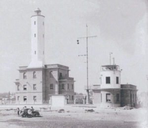
Code: IT_RA_05
Location / Address: Viale delle Nazioni, 12, 48123 Ravenna RA"
Date of mapping: 18/11/2019
Property tipology: Public
State of occupancy: Occupied
State of preservation: Need of minor interventions on non-structural elements - (Score = 2)
Level of practicability: None - (Score = 0)
Surrounding area: No - (Score = 0)
It may be possible, subject to authorization from the competent body, to organize dissemination events by temporarily opening some of the rooms inside and the garden area.
Construction era: Contemporary Era (XIX a.C. – Today)
Buried archaeological remains: Absence of buried Archaeological remains or absence of Archaeological information about the site – (Score = 0);
The Marina di Ravenna lighthouse was lit for the first time on 12/06/1862, the so-called lighthouse lighting period, and is an integral part of the infrastructure of the San Vitale port, still in use today and together with the headquarters of the control tower of the port pilots and maritime signaller is one of the reference points for access to the port area.
The lighthouse is an integral part of the fishing boat dock of Marina di Ravenna and together with it forms the first nucleus of the port. Not far away is the fish market, pine forests and nature trails linked to the valleys and dunes.
Distance: 1 km < D < 2 km
Organisation of internal spaces (related to "final intended use"): The layout of the lighthouse corresponds to what is reported in the attached historical plans dating back to the time of construction. The only element that has been modified, probably at the same time as the construction of the fish market, is the tower, which has been raised by two levels.
Structure and Material Characteristics: Bearing Masonry
State of the structure: The structure is load-bearing in sight.
Electrical System: Presence of a public network in the Surrounding Area, presence of connections to the public network, presence of systems in the Infrastructure/Building/Archeologic Site – (Score = 3)
Sanitary Installation: Presence of a public network in the Surrounding Area, presence of connections to the public network, presence of systems in the Infrastructure/Building/Archeologic Site – (Score = 3)
Gasworks: Presence of a public network in the Surrounding Area, presence of connections to the public network, presence of systems in the Infrastructure/Building/Archeologic Site – (Score = 3)
Existing infrastructure for private mobility: Presence of a paved road that lead to the Infrastructure/Building/Archeological Site and of a parking in the surrounding area – (Score = 3)
Presence of a bicycle lane: yes
Existing infrastructure for public means of transport: Easy to attain with public MoT (>500 and <1km) – (Score = 2)
The infrastructure/building/Archeological Site is considered as “Bounded Heritage”: no
Which is the level of complexity of the administrative procedures to be adopted to manage it in terms of renovation/retrofit or Temporary Uses activation?: Complicated – (Score = 0)
Any intervention must be of public initiative, or subject to public evidence.
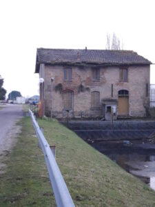
Code: IT_RA_04
Location / Address: Via Cimitero, Area Industriale - RA
Date of mapping: 18/11/2019
Property tipology: Public
State of occupancy: Abandoned
State of preservation: Mostly rickety/unsafe - (Score = 0)
Level of practicability: None - (Score = 0)
Surrounding area: Yes - (Score = 1)
The dewatering pump is managed by the Consorzio di Bonifica, a public body which controls water regulation. Currently the plant is stopped and the building is in a state of decay. All around there are green spaces and areas that could be subject to enhancement also in relation to the location, subject to verification of the availability of the area.
Construction era: Contemporary Era (XIX a.C. – Today)
Buried archaeological remains: Absence of buried Archaeological remains or absence of Archaeological information about the site – (Score = 0);
The Fagiolo dewatering pump was built by the Consorzio di Bonifica in the early 1900s, apparently in 1901, during an important reclamation operation in the Ravenna area. Over the course of about 30 years, the Consortium built various plants, including the gravel ditch plant at Madonna del Pino in Cervia, the Rasponi plant in Punta Marina and San Vitale in Marina di Ravenna. The plants have dried important parts of the Ravenna area by means of mechanical reclamation, faster than by reclamation by filling.
The dewatering pump is near the monument to the fallen at sea and the monumental cemetery of Ravenna; it is accessible from Via del Cimitero and also from the long quay, which however is not in continuity with that of the city dock, as they are separated by the mobile bridge. The indicated proximity refers to the two monumental sites mentioned. Compared to the main tourist attractions as well as monuments of the historic city, we are instead at D> 3 Km.
Distance: D < 1 km
Organisation of internal spaces (related to "final intended use"): The building is not accessible, as it is unsafe. It consists of a small masonry volume on two levels. Presumably, given the common typology of similar systems, built at the beginning of the twentieth century, the ground floor could consist of a single room to house the lifting system. Pictures of the facility are attached.
Structure and Material Characteristics: Bearing Masonry
State of the structure: The supporting structure is in masonry. The roof covering is in brick. The building is not in a good state of conservation.
Electrical System: Presence of a public network in the Surrounding Area, total lack of systems in the Infrastructure/Building/Archeological Site, total lack of connections to the public network – (Score = 1)
Sanitary Installation: Presence of a public network in the Surrounding Area, total lack of systems in the Infrastructure/Building/Archeological Site, total lack of connections to the public network – (Score = 1)
Gasworks: Presence of a public network in the Surrounding Area, total lack of systems in the Infrastructure/Building/Archeological Site, total lack of connections to the public network – (Score = 1)
Existing infrastructure for private mobility: Presence of a paved road that lead to the Infrastructure/Building/Archeological Site and of a parking in the surrounding area – (Score = 3)
Presence of a bicycle lane: yes
Existing infrastructure for public means of transport: close to public MoT (<500 m) – (Score = 3)
The infrastructure/building/Archeological Site is considered as “Bounded Heritage”: no
Which is the level of complexity of the administrative procedures to be adopted to manage it in terms of renovation/retrofit or Temporary Uses activation?: Complicated – (Score = 0)
The intervention on the structure aimed at a possible temporary reuse must first of all provide for the safety of the same. The complexity could derive mainly from an economic factor, unless the institution is willing to proceed with a shared planning, with a view to enhancing the heritage relating to the evidence of the mechanical reclamation carried out thanks to the water pumps of the early twentieth century.
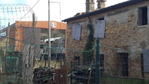
Code: IT_RA_02
Location / Address: via del Marchesato, Marina di Ravenna - RA
Date of mapping: 18/11/2019
Property tipology: Public
State of occupancy: Abandoned
State of preservation: Mostly rickety/unsafe - (Score = 0)
Level of practicability: None - (Score = 0)
Surrounding area: Yes - (Score = 1)
It is possible to think of using only two portions of the external garden.
Construction era: Modern Era (XV – XVIII a.C.)
Buried archaeological remains: Absence of buried Archaeological remains or absence of Archaeological information about the site – (Score = 0);
Built in 1764 to a design by Antonio Farini, it was a building that performed public functions in relation to port activities and was known as the Casa della Sanità. In 1765 the marquis Cavalli built another building next to the "Casone" which since then became "the Fabbrica Vecchia" to distinguish it from the "Fabbrica Nuova" of the marquises Cavalli which was used as a warehouse, inn and tax collection office for the marquises. Hence the denomination the "Marchesato". At the end of the 19th century, the building was used as the headquarters of the Harbor Master's Office, but following the development of the port structures, the garrison of the old factory was gradually abandoned.
Fishing boat Darsena and Marina di Ravenna lighthouse, breakwaters of the San Vitale port, historic pine forests of the Natura 2000 network.
Distance: 1 km < D < 2 km
Organisation of internal spaces (related to "final intended use"): It is not possible to access the structure internally to check its layout. The function covered by the structure has always been public.
Structure and Material Characteristics: Bearing Masonry
State of the structure: Load-bearing masonry structure made with solid brick masonry, simple frame wooden floor and wooden truss roof.
Electrical System: Total lack of systems in the Infrastructure/Building/Archeological Site, total lack of connections to the public network and absence of a public network in the surrounding area – (Score = 0)
Sanitary Installation: Presence of a public network in the Surrounding Area, total lack of systems in the Infrastructure/Building/Archeological Site, total lack of connections to the public network – (Score = 1)
Gasworks: Total lack of systems in the Infrastructure/Building/Archeological Site, total lack of connections to the public network and absence of a public network in the surrounding area – (Score = 0)
Existing infrastructure for private mobility: Presence of a dirt road that lead to the Infrastructure/Building/Archeological Site, absence of a paved road and of a parking – (Score = 1)
Presence of a bicycle lane: no
Existing infrastructure for public means of transport: Difficult to attain public MoT (>1 and <3 km) – (Score = 1)
The infrastructure/building/Archeological Site is considered as “Bounded Heritage”: yes
Which is the level of complexity of the administrative procedures to be adopted to manage it in terms of renovation/retrofit or Temporary Uses activation?: Complicated – (Score = 0)
Building bound by Legislative Decree 42/2004 Cultural Heritage Code
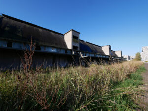
Code: IT_RA_01
Location / Address:
Via Bosi Maramotti, Ravenna - RA
Date of mapping: 18/11/2019
Property tipology: Private
State of occupancy: Abandoned
State of preservation: Mostly rickety/unsafe - (Score = 0)
Level of practicability: None - (Score = 0)
Surrounding area: Yes - (Score = 1)
Classified by the POC Darsena as an area already investigated and to be reclaimed (TAV C13 of the information framework). It is possible to evaluate the use of an area outside the building, net of securing the outside areas. There is a portion of the external surrounding area (width = 10-12 m, length = 150 m) which can be used for Temporary Uses. A portion of this area (4-5 meters wide) is adjacent to the building and is not safe due to the height of the building.
Construction era: Contemporary Era (XIX a.C. – Today)
Buried archaeological remains: Absence of buried Archaeological remains or absence of Archaeological information about the site – (Score = 0);
The building was built in 1956, it consists of a single building of m. 175.00 in length per m. 30.00 wide, with a parabolic vault with a maximum net height of m. 17.35.
Over time, the property has had the function of warehouse for bulk storage of finished products. The building is subject to restrictions pursuant to Legislative Decree 42/2004 (Excerpt from the cognitive framework of the thematic POC Darsena di Città, TAVC26 ) - See attached photos.
The building is within a sector affected by redevelopment interventions that have taken place in the last 20 years. Directly connected to the quay, it is located a short distance from meeting places (Darsena POPUP, Darsenale etc...) and from the Almagià theater for contemporary arts.
Distance: D < 1 km
Organisation of internal spaces (related to "final intended use"): The building is not accessible, but from documentary sources it is clear that the internal distribution develops in a single volume/environment, in accordance with the intended use as a warehouse which has remained unchanged over time.
Structure and Material Characteristics: Reinforced Concrete frame structure
State of the structure: The supporting structure is made up of a succession of 34 arched frames arranged transversally with respect to the longitudinal axis of the former warehouse. Within each structural module, the arches are connected to each other by brick and concrete floors which develop from an altitude of + 7.20 up to the top of the shed located at an altitude of + 17.35.
Electrical System: Presence of a public network in the Surrounding Area, total lack of systems in the Infrastructure/Building/Archeological Site, total lack of connections to the public network – (Score = 1)
Sanitary Installation: Presence of a public network in the Surrounding Area, total lack of systems in the Infrastructure/Building/Archeological Site, total lack of connections to the public network – (Score = 1)
Gasworks: Presence of a public network in the Surrounding Area, total lack of systems in the Infrastructure/Building/Archeological Site, total lack of connections to the public network – (Score = 1)
Existing infrastructure for private mobility: Presence of a paved road that lead to the Infrastructure/Building/Archeological Site and of a parking in the surrounding area – (Score = 3)
Presence of a bicycle lane: yes
Existing infrastructure for public means of transport: close to public MoT (<500 m) – (Score = 3)
The infrastructure/building/Archeological Site is considered as “Bounded Heritage”: yes
Which is the level of complexity of the administrative procedures to be adopted to manage it in terms of renovation/retrofit or Temporary Uses activation?: Complicated – (Score = 0)
Each intervention must comply with the legislation for the protection of Architectural and Landscape Heritage
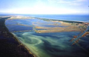
Code: IT4070004
Name of element: Pialasse Baiona, Risega e Pontazzo
Date of the protection act:: 22/09/2003
Motivation of the protection: Ampia laguna salmastra a contatto con il mare tramite canali, con acque a bassa profondità e fondali limoso-argillosi. Il sito racchiude un campionario pressochè completo di successioni sublitoranee a diverso gradiente di umidità e salinità, delle quali un raro, prezioso esempio è concentrato presso il Prato barenicolo "Pietro Zangheri", al margine nord-orientale della Baiona. La porzione del sito compresa tra Via delle Valli e Via delle Industrie è considerata zona umida di importanza internazionale ai sensi della Convenzione di Ramsar. Il sito risulta incluso nel Parco Regionale del Delta del Po. Il sito comprende 10 habitat di interesse comunitario, 3 dei quali prioritari, coprono circa il 78% della superficie del sito, prevalentemente acquatici salmastri e non. Specie vegetali RARE e MINACCIATE: Erianthus ravennae, Plantago cornuti, Limonium bellidifolium. Importante sito di alimentazione della colonia di Egretta garzetta delle vicine garzaie di Punte Alberete e Pineta di San Vitale. Sono presenti piccole popolazioni nidificanti di molte specie di Charadriiformes: Recurvirostra avosetta, Himantopus himantopus, Charadrius alexandrinus, Tringa totanus, Sterna albifrons, Tadorna tadorna. Più numerosa la popolazione di Sterna hirundo. Il ripristino di dossi ha permesso l'insediamento (irregolare) di interessanti popolazioni nidificanti di Larus melanocephalus, Larus genei, Gelochelodon nilotica. È uno dei pochi siti in Italia di nidificazione di Netta rufina. La popolazione di Aphanius fasciatus appare molto abbondante e vitale.
Level of identification of the area as heritage by the community: L’unicità, le caratteristiche peculiari di quest’area, la localizzazione industriale legata al fattore costa e lo sviluppo del porto di Ravenna hanno reso questo sito meta del turismo di massa. Essa è anche destinazione di appassionati di bird-watching.
Historical value: preserved
Historical value motivation: Le Pialasse si sono formate a partire dal Rinascimento e devono le loro caratteristiche e l’attuale assetto in gran parte all’azione umana. All’interno della Pialassa è collocato il Capanno Garibaldi, che deve il nome proprio a Giuseppe Garibaldi.
Cultural value: preserved
Cultural value motivation: In queste zone, l’attività antropica principale è sempre stata la pesca, sviluppatasi lungo i fi umi e nelle zone umide abbastanza profonde da accogliere diverse specie ittiche. Senza dubbio, la struttura-emblema della pesca tradizionale è il bilancione, tipico capanno da pesca con rete a bilanca;
Natural value: preserved
Natural value motivation: la varietà ambientale che caratterizza questi siti è estremamente complessa, eterogenea e basata su funzionamenti ecosistemici dagli equilibri molto delicati. Nel suo piccolo, dovuto allo spazio limitato, sono censite in Baiona 231 specie, delle quali ben 17 inserite nella lista regionale delle specie target per la conservazione.
Morphological value: preserved
Morphological value motivation:
Aesthetic value: preserved
Aesthetic value motivation: I continui interventi antropici che sin dalla prima metà del Novecento con opera di bonifica, la successiva localizzazione industriale avvenuta negli anni ’50 hanno modificato l’assetto dell’area mantenendone comunque il suo peculiare valore estetico.
Institution/Body in charge of the management of the site: Regione Emilia-Romagna - Direzione Generale Ambiente, Difesa del Suolo e della Costa - Servizio Parchi e Risorse forestali
Viale della Fiera, 8 - 40127 Bologna
segrprn@regione.emilia-romagna.it
Main Cultural/Touristic points of interest within the site: La presenza dei vecchi capanni da pesca all’interno della Pialassa della Baiona racconta parte della storia del territorio ravennate: uno degli episodi forse più famosi è legato a Giuseppe Garibaldi che, fuggiasco per le nostre valli, trovò ospitalità proprio in un capanno che oggi è aperto al pubblico.
Is it possible to visit the site?: yes
Accessibility with reference to existing infrastructures in the Surrounding area for private mobility (car, bicycles, etc.):: Presence of a paved road that lead to the Infrastructure/Building/Archeological Site and of a parking in the surrounding area
Presence of a bicycle lane: yes
Accessibility with reference to existing infrastructures for public means of transport - MoT (collective transport: bus, train, etc.): close to public MoT (<500 m)
Time of the survey:
Code: IT_RA_00
Location / Address: via delle industrie 107
Date of mapping:
Property tipology: Private
State of occupancy: Abandoned
State of preservation: Ruin - (Score = 0)
Level of practicability: None - (Score = 0)
Surrounding area: Yes - (Score = 1)
Construction era: Contemporary Era (XIX a.C. – Today)
Buried archaeological remains: Absence of buried Archaeological remains or absence of Archaeological information about the site – (Score = 0);
Organisation of internal spaces (related to "final intended use"):
Structure and Material Characteristics: Bearing Masonry
State of the structure:
Electrical System: Total lack of systems in the Infrastructure/Building/Archeological Site, total lack of connections to the public network and absence of a public network in the surrounding area – (Score = 0)
Sanitary Installation: Total lack of systems in the Infrastructure/Building/Archeological Site, total lack of connections to the public network and absence of a public network in the surrounding area – (Score = 0)
Gasworks: Total lack of systems in the Infrastructure/Building/Archeological Site, total lack of connections to the public network and absence of a public network in the surrounding area – (Score = 0)
Existing infrastructure for private mobility: Total lack of roads and parkings that lead to the Infrastructure/Building/Archeological Site – (Score = 0)
Presence of a bicycle lane: no
Existing infrastructure for public means of transport: Unattainable with public MoT (>3km) – (Score = 0)
The infrastructure/building/Archeological Site is considered as “Bounded Heritage”: no
Which is the level of complexity of the administrative procedures to be adopted to manage it in terms of renovation/retrofit or Temporary Uses activation?: Facilitated – (Score = 2)
Code: IT_RA_03
Location / Address: Via Baiona, 48123 Area Industriale RA
Date of mapping: 08/02/2020
Property tipology: Public
State of occupancy: Occupied
State of preservation: Well preserved (no need of intervention) - (Score = 3)
Level of practicability: Total - (Score = 1)
Surrounding area: Yes - (Score = 1)
Il capanno Garibaldi è gestito dalla Società Conservatrice, associazione che agisce per la conservazione e valorizzazione dello stesso , mediante organizzazione di attività culturali , turistiche e didattiche. Nello spazio esterno vengono organizzati eventi. Sarebbe interessante metterli in rete con altre località che favoriscano il turismo lento e sostenibile delle valli.
Construction era: Contemporary Era (XIX a.C. – Today)
Buried archaeological remains: Absence of buried Archaeological remains or absence of Archaeological information about the site – (Score = 0);
Il Capanno viene costruito nel 1810 come rifugio per la caccia; nel 1844 è ricostruito in muratura dopo un incendio. Nel 1849 diviene rifugio per Giuseppe Garibaldi che, in fuga da Roma, tentava di raggiungere Venezia e, per sfuggire agli austriaci, venne nascosto in terra romagnola. Il capanno diventa così uno dei luoghi della "trafila" garibaldina e in un secondo momento, anche monumento della città di Ravenna, in quanto posto sotto tutela della Soprindendenza. E' in buono stato di conservazione e attualmente è gestito da una associazione che lo promuove mediante iniziative ed eventi.
Il rifugio si trova all'interno del Parco del Delta del Po. Nelle vicinanze partono diversi sentieri e il Rifugio è una tappa di uno di questi.
Distance: D < 1 km
Organisation of internal spaces (related to "final intended use"): l'edificio è accessibile, ed è costituito da un piccolo volume in muratura formato da due ambienti collegati a piano terra, un soppalco ligneo e una importante copertura in canna valliva. Si allegano immagini dell'ambiete esterno ed interno.
Structure and Material Characteristics: Bearing Masonry
State of the structure: La struttura portante è in muratura. La copertura è realizzata in legno e il manto in canna valliva. Si trova in buono stato di conservazione.
Electrical System: Presence of a public network in the Surrounding Area, presence of connections to the public network, presence of systems in the Infrastructure/Building/Archeologic Site – (Score = 3)
Sanitary Installation: Presence of a public network in the Surrounding Area, presence of connections to the public network, presence of systems in the Infrastructure/Building/Archeologic Site – (Score = 3)
Gasworks: Total lack of systems in the Infrastructure/Building/Archeological Site, total lack of connections to the public network and absence of a public network in the surrounding area – (Score = 0)
Existing infrastructure for private mobility: Presence of a paved road that lead to the Infrastructure/Building/Archeological Site and of a parking in the surrounding area – (Score = 3)
Presence of a bicycle lane: yes
Existing infrastructure for public means of transport: Unattainable with public MoT (>3km) – (Score = 0)
The infrastructure/building/Archeological Site is considered as “Bounded Heritage”: yes
Which is the level of complexity of the administrative procedures to be adopted to manage it in terms of renovation/retrofit or Temporary Uses activation?: Complicated – (Score = 0)
Ogni intervento deve essere conforme alla normativa per la tutela dei Beni Architettonici e del Paesaggio. La struttura è gestita da una Associazione che ne promuove la tutela e la valorizzazione.
Click on the marker on the map to get more info about the cultural or natural heritage point of interest.
The aim of the mapping is to evaluate the convenience to regenerate/reactivate a Site through Temporary Uses (TUs).